You are here: Home > Network List > TA - USArray Transportable Network (new EarthScope stations) Stations List
> Station 133A Hamilton Ranch, Breckenridge, TX, USA > Earthquake Result Viewer
133A Hamilton Ranch, Breckenridge, TX, USA - Earthquake Result Viewer
| Earthquake location: |
Near Coast Of Central Chile |
| Earthquake latitude/longitude: |
-36.7/-73.4 |
| Earthquake time(UTC): |
2010/03/05 (064) 11:47:06 GMT |
| Earthquake Depth: |
18 km |
| Earthquake Magnitude: |
6.1 MB, 6.7 MS, 6.6 MW, 6.6 MW |
| Earthquake Catalog/Contributor: |
WHDF/NEIC |
|
| Network: |
TA USArray Transportable Network (new EarthScope stations) |
| Station: |
133A Hamilton Ranch, Breckenridge, TX, USA |
| Lat/Lon: |
32.61 N/98.92 W |
| Elevation: |
418 m |
|
| Distance: |
72.9 deg |
| Az: |
337.624 deg |
| Baz: |
158.736 deg |
| Ray Param: |
0.05331781 |
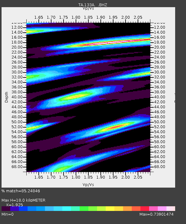
| Estimated Moho Depth: |
18.0 km |
| Estimated Crust Vp/Vs: |
1.92 |
| Assumed Crust Vp: |
6.426 km/s |
| Estimated Crust Vs: |
3.338 km/s |
| Estimated Crust Poisson's Ratio: |
0.32 |
|
| Radial Match: |
85.24846 % |
| Radial Bump: |
400 |
| Transverse Match: |
55.08576 % |
| Transverse Bump: |
400 |
| SOD ConfigId: |
299721 |
| Insert Time: |
2010-04-26 17:12:55.564 +0000 |
| GWidth: |
2.5 |
| Max Bumps: |
400 |
| Tol: |
0.001 |
|

Signal To Noise
| Channel | StoN | STA | LTA |
| TA:133A: :BHZ:20100305T11:58:03.700005Z | 2.828115 | 3.8740902E-7 | 1.369849E-7 |
| TA:133A: :BHN:20100305T11:58:03.700005Z | 3.351013 | 4.847044E-7 | 1.4464415E-7 |
| TA:133A: :BHE:20100305T11:58:03.700005Z | 1.3369297 | 3.73706E-7 | 2.7952555E-7 |
| Arrivals |
| Ps | 2.7 SECOND |
| PpPs | 7.9 SECOND |
| PsPs/PpSs | 11 SECOND |


