You are here: Home > Network List > N4 - Central and EAstern US Network Stations List
> Station P38B Dawn, MO, USA > Earthquake Result Viewer
P38B Dawn, MO, USA - Earthquake Result Viewer
| Earthquake location: |
Samoa Islands Region |
| Earthquake latitude/longitude: |
-15.4/-173.0 |
| Earthquake time(UTC): |
2022/12/04 (338) 19:24:15 GMT |
| Earthquake Depth: |
36 km |
| Earthquake Magnitude: |
6.7 Mww |
| Earthquake Catalog/Contributor: |
NEIC PDE/us |
|
| Network: |
N4 Central and EAstern US Network |
| Station: |
P38B Dawn, MO, USA |
| Lat/Lon: |
39.62 N/93.53 W |
| Elevation: |
248 m |
|
| Distance: |
91.8 deg |
| Az: |
49.43 deg |
| Baz: |
251.562 deg |
| Ray Param: |
0.041552763 |
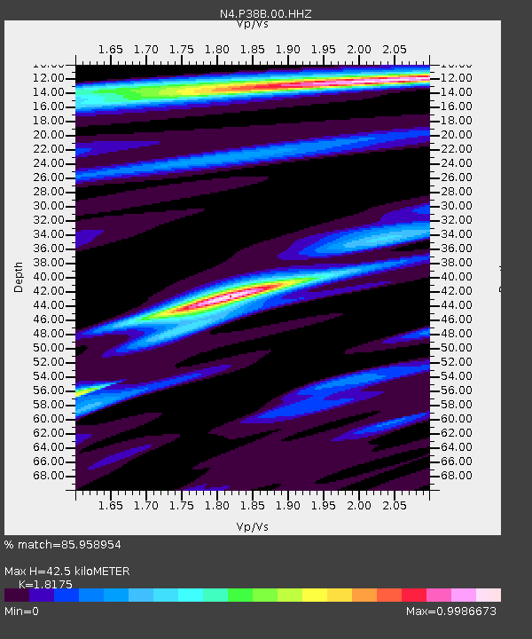
| Estimated Moho Depth: |
42.5 km |
| Estimated Crust Vp/Vs: |
1.82 |
| Assumed Crust Vp: |
6.498 km/s |
| Estimated Crust Vs: |
3.575 km/s |
| Estimated Crust Poisson's Ratio: |
0.28 |
|
| Radial Match: |
85.958954 % |
| Radial Bump: |
380 |
| Transverse Match: |
64.98843 % |
| Transverse Bump: |
400 |
| SOD ConfigId: |
29823551 |
| Insert Time: |
2022-12-18 20:42:15.125 +0000 |
| GWidth: |
2.5 |
| Max Bumps: |
400 |
| Tol: |
0.001 |
|

Signal To Noise
| Channel | StoN | STA | LTA |
| N4:P38B:00:HHZ:20221204T19:36:47.988985Z | 8.801916 | 2.3722894E-6 | 2.6951963E-7 |
| N4:P38B:00:HH1:20221204T19:36:47.988985Z | 1.5531088 | 3.8243016E-7 | 2.4623526E-7 |
| N4:P38B:00:HH2:20221204T19:36:47.988985Z | 3.010519 | 7.090605E-7 | 2.3552765E-7 |
| Arrivals |
| Ps | 5.5 SECOND |
| PpPs | 18 SECOND |
| PsPs/PpSs | 24 SECOND |


