You are here: Home > Network List > N4 - Central and EAstern US Network Stations List
> Station P46A Rosedale, IN, USA > Earthquake Result Viewer
P46A Rosedale, IN, USA - Earthquake Result Viewer
| Earthquake location: |
Samoa Islands Region |
| Earthquake latitude/longitude: |
-15.4/-173.0 |
| Earthquake time(UTC): |
2022/12/04 (338) 19:24:15 GMT |
| Earthquake Depth: |
36 km |
| Earthquake Magnitude: |
6.7 Mww |
| Earthquake Catalog/Contributor: |
NEIC PDE/us |
|
| Network: |
N4 Central and EAstern US Network |
| Station: |
P46A Rosedale, IN, USA |
| Lat/Lon: |
39.62 N/87.21 W |
| Elevation: |
194 m |
|
| Distance: |
96.5 deg |
| Az: |
50.825 deg |
| Baz: |
255.482 deg |
| Ray Param: |
0.04049176 |
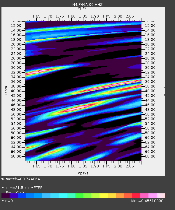
| Estimated Moho Depth: |
31.5 km |
| Estimated Crust Vp/Vs: |
1.66 |
| Assumed Crust Vp: |
6.444 km/s |
| Estimated Crust Vs: |
3.888 km/s |
| Estimated Crust Poisson's Ratio: |
0.21 |
|
| Radial Match: |
80.744064 % |
| Radial Bump: |
400 |
| Transverse Match: |
58.7714 % |
| Transverse Bump: |
400 |
| SOD ConfigId: |
29823551 |
| Insert Time: |
2022-12-18 20:42:18.910 +0000 |
| GWidth: |
2.5 |
| Max Bumps: |
400 |
| Tol: |
0.001 |
|

Signal To Noise
| Channel | StoN | STA | LTA |
| N4:P46A:00:HHZ:20221204T19:37:09.329012Z | 4.0074725 | 1.2329502E-6 | 3.076628E-7 |
| N4:P46A:00:HH1:20221204T19:37:09.329012Z | 1.9314942 | 6.4924126E-7 | 3.3613418E-7 |
| N4:P46A:00:HH2:20221204T19:37:09.329012Z | 2.4747262 | 5.2926777E-7 | 2.1386923E-7 |
| Arrivals |
| Ps | 3.3 SECOND |
| PpPs | 13 SECOND |
| PsPs/PpSs | 16 SECOND |


