You are here: Home > Network List > TA - USArray Transportable Network (new EarthScope stations) Stations List
> Station 233A Rising Star, TX, USA > Earthquake Result Viewer
233A Rising Star, TX, USA - Earthquake Result Viewer

| Earthquake location: |
Near Coast Of Central Chile |
| Earthquake latitude/longitude: |
-36.7/-73.4 |
| Earthquake time(UTC): |
2010/03/05 (064) 11:47:06 GMT |
| Earthquake Depth: |
18 km |
| Earthquake Magnitude: |
6.1 MB, 6.7 MS, 6.6 MW, 6.6 MW |
| Earthquake Catalog/Contributor: |
WHDF/NEIC |
|
| Network: |
TA USArray Transportable Network (new EarthScope stations) |
| Station: |
233A Rising Star, TX, USA |
| Lat/Lon: |
32.02 N/98.90 W |
| Elevation: |
539 m |
|
| Distance: |
72.4 deg |
| Az: |
337.413 deg |
| Baz: |
158.682 deg |
| Ray Param: |
0.053680714 |
| Estimated Moho Depth: |
41.5 km |
| Estimated Crust Vp/Vs: |
1.68 |
| Assumed Crust Vp: |
6.426 km/s |
| Estimated Crust Vs: |
3.831 km/s |
| Estimated Crust Poisson's Ratio: |
0.22 |
|
| Radial Match: |
80.91787 % |
| Radial Bump: |
400 |
| Transverse Match: |
79.252365 % |
| Transverse Bump: |
400 |
| SOD ConfigId: |
299721 |
| Insert Time: |
2010-04-26 17:13:27.992 +0000 |
| GWidth: |
2.5 |
| Max Bumps: |
400 |
| Tol: |
0.001 |
|
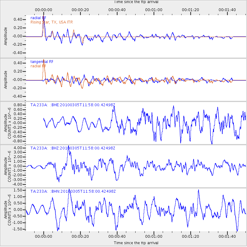
Signal To Noise
| Channel | StoN | STA | LTA |
| TA:233A: :BHZ:20100305T11:58:00.42498Z | 2.712606 | 5.40209E-7 | 1.9914762E-7 |
| TA:233A: :BHN:20100305T11:58:00.42498Z | 1.5202904 | 4.0499359E-7 | 2.6639225E-7 |
| TA:233A: :BHE:20100305T11:58:00.42498Z | 1.2522101 | 2.2105948E-7 | 1.7653544E-7 |
| Arrivals |
| Ps | 4.5 SECOND |
| PpPs | 17 SECOND |
| PsPs/PpSs | 21 SECOND |


