You are here: Home > Network List > N4 - Central and EAstern US Network Stations List
> Station T35B Sooner Cattle Company, Foraker, OK, USA > Earthquake Result Viewer
T35B Sooner Cattle Company, Foraker, OK, USA - Earthquake Result Viewer
| Earthquake location: |
Samoa Islands Region |
| Earthquake latitude/longitude: |
-15.4/-173.0 |
| Earthquake time(UTC): |
2022/12/04 (338) 19:24:15 GMT |
| Earthquake Depth: |
36 km |
| Earthquake Magnitude: |
6.7 Mww |
| Earthquake Catalog/Contributor: |
NEIC PDE/us |
|
| Network: |
N4 Central and EAstern US Network |
| Station: |
T35B Sooner Cattle Company, Foraker, OK, USA |
| Lat/Lon: |
36.92 N/96.51 W |
| Elevation: |
413 m |
|
| Distance: |
88.7 deg |
| Az: |
51.203 deg |
| Baz: |
249.716 deg |
| Ray Param: |
0.04236619 |
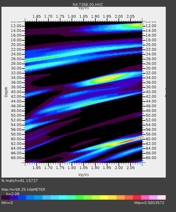
| Estimated Moho Depth: |
59.25 km |
| Estimated Crust Vp/Vs: |
2.09 |
| Assumed Crust Vp: |
6.483 km/s |
| Estimated Crust Vs: |
3.102 km/s |
| Estimated Crust Poisson's Ratio: |
0.35 |
|
| Radial Match: |
91.15727 % |
| Radial Bump: |
369 |
| Transverse Match: |
79.93174 % |
| Transverse Bump: |
400 |
| SOD ConfigId: |
29823551 |
| Insert Time: |
2022-12-18 20:42:39.402 +0000 |
| GWidth: |
2.5 |
| Max Bumps: |
400 |
| Tol: |
0.001 |
|

Signal To Noise
| Channel | StoN | STA | LTA |
| N4:T35B:00:HHZ:20221204T19:36:33.569979Z | 9.759018 | 2.7093188E-6 | 2.7762206E-7 |
| N4:T35B:00:HH1:20221204T19:36:33.569979Z | 3.9646864 | 6.837483E-7 | 1.7245961E-7 |
| N4:T35B:00:HH2:20221204T19:36:33.569979Z | 3.3241742 | 8.730315E-7 | 2.626311E-7 |
| Arrivals |
| Ps | 10 SECOND |
| PpPs | 28 SECOND |
| PsPs/PpSs | 38 SECOND |


