You are here: Home > Network List > N4 - Central and EAstern US Network Stations List
> Station TUL3 Leonard, OK, USA > Earthquake Result Viewer
TUL3 Leonard, OK, USA - Earthquake Result Viewer
| Earthquake location: |
Samoa Islands Region |
| Earthquake latitude/longitude: |
-15.4/-173.0 |
| Earthquake time(UTC): |
2022/12/04 (338) 19:24:15 GMT |
| Earthquake Depth: |
36 km |
| Earthquake Magnitude: |
6.7 Mww |
| Earthquake Catalog/Contributor: |
NEIC PDE/us |
|
| Network: |
N4 Central and EAstern US Network |
| Station: |
TUL3 Leonard, OK, USA |
| Lat/Lon: |
35.91 N/95.79 W |
| Elevation: |
265 m |
|
| Distance: |
88.9 deg |
| Az: |
52.345 deg |
| Baz: |
250.166 deg |
| Ray Param: |
0.042221196 |
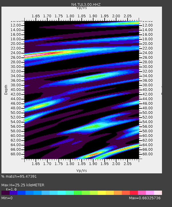
| Estimated Moho Depth: |
25.25 km |
| Estimated Crust Vp/Vs: |
1.60 |
| Assumed Crust Vp: |
6.498 km/s |
| Estimated Crust Vs: |
4.061 km/s |
| Estimated Crust Poisson's Ratio: |
0.18 |
|
| Radial Match: |
95.47391 % |
| Radial Bump: |
396 |
| Transverse Match: |
87.90897 % |
| Transverse Bump: |
400 |
| SOD ConfigId: |
29823551 |
| Insert Time: |
2022-12-18 20:42:47.211 +0000 |
| GWidth: |
2.5 |
| Max Bumps: |
400 |
| Tol: |
0.001 |
|

Signal To Noise
| Channel | StoN | STA | LTA |
| N4:TUL3:00:HHZ:20221204T19:36:34.519015Z | 20.664223 | 2.9081912E-6 | 1.4073557E-7 |
| N4:TUL3:00:HH1:20221204T19:36:34.519015Z | 1.8626378 | 4.2251094E-7 | 2.2683474E-7 |
| N4:TUL3:00:HH2:20221204T19:36:34.519015Z | 7.1952014 | 8.21831E-7 | 1.1421932E-7 |
| Arrivals |
| Ps | 2.4 SECOND |
| PpPs | 9.9 SECOND |
| PsPs/PpSs | 12 SECOND |


