You are here: Home > Network List > O2 - Oklahoma Consolidated Temporary Seismic Networks Stations List
> Station CRES Cresent, Oklahoma, USA > Earthquake Result Viewer
CRES Cresent, Oklahoma, USA - Earthquake Result Viewer
| Earthquake location: |
Samoa Islands Region |
| Earthquake latitude/longitude: |
-15.4/-173.0 |
| Earthquake time(UTC): |
2022/12/04 (338) 19:24:15 GMT |
| Earthquake Depth: |
36 km |
| Earthquake Magnitude: |
6.7 Mww |
| Earthquake Catalog/Contributor: |
NEIC PDE/us |
|
| Network: |
O2 Oklahoma Consolidated Temporary Seismic Networks |
| Station: |
CRES Cresent, Oklahoma, USA |
| Lat/Lon: |
36.04 N/97.53 W |
| Elevation: |
311 m |
|
| Distance: |
87.6 deg |
| Az: |
51.735 deg |
| Baz: |
249.128 deg |
| Ray Param: |
0.043168943 |
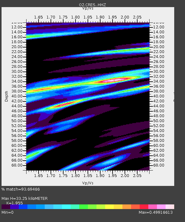
| Estimated Moho Depth: |
33.25 km |
| Estimated Crust Vp/Vs: |
1.96 |
| Assumed Crust Vp: |
6.483 km/s |
| Estimated Crust Vs: |
3.316 km/s |
| Estimated Crust Poisson's Ratio: |
0.32 |
|
| Radial Match: |
93.69466 % |
| Radial Bump: |
265 |
| Transverse Match: |
70.024574 % |
| Transverse Bump: |
400 |
| SOD ConfigId: |
29823551 |
| Insert Time: |
2022-12-18 20:45:49.593 +0000 |
| GWidth: |
2.5 |
| Max Bumps: |
400 |
| Tol: |
0.001 |
|

Signal To Noise
| Channel | StoN | STA | LTA |
| O2:CRES: :HHZ:20221204T19:36:28.439974Z | 8.408751 | 2.9422586E-6 | 3.499044E-7 |
| O2:CRES: :HHN:20221204T19:36:28.439974Z | 1.7556216 | 9.0676576E-7 | 5.164927E-7 |
| O2:CRES: :HHE:20221204T19:36:28.439974Z | 3.6705637 | 1.015183E-6 | 2.7657413E-7 |
| Arrivals |
| Ps | 5.0 SECOND |
| PpPs | 15 SECOND |
| PsPs/PpSs | 20 SECOND |


