You are here: Home > Network List > O2 - Oklahoma Consolidated Temporary Seismic Networks Stations List
> Station FW01 Cuddy Creek, Oklahoma, USA > Earthquake Result Viewer
FW01 Cuddy Creek, Oklahoma, USA - Earthquake Result Viewer
| Earthquake location: |
Samoa Islands Region |
| Earthquake latitude/longitude: |
-15.4/-173.0 |
| Earthquake time(UTC): |
2022/12/04 (338) 19:24:15 GMT |
| Earthquake Depth: |
36 km |
| Earthquake Magnitude: |
6.7 Mww |
| Earthquake Catalog/Contributor: |
NEIC PDE/us |
|
| Network: |
O2 Oklahoma Consolidated Temporary Seismic Networks |
| Station: |
FW01 Cuddy Creek, Oklahoma, USA |
| Lat/Lon: |
36.49 N/98.94 W |
| Elevation: |
431 m |
|
| Distance: |
86.7 deg |
| Az: |
50.895 deg |
| Baz: |
248.258 deg |
| Ray Param: |
0.043817516 |
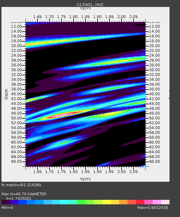
| Estimated Moho Depth: |
48.75 km |
| Estimated Crust Vp/Vs: |
1.74 |
| Assumed Crust Vp: |
6.426 km/s |
| Estimated Crust Vs: |
3.688 km/s |
| Estimated Crust Poisson's Ratio: |
0.25 |
|
| Radial Match: |
93.324265 % |
| Radial Bump: |
333 |
| Transverse Match: |
85.31582 % |
| Transverse Bump: |
400 |
| SOD ConfigId: |
29823551 |
| Insert Time: |
2022-12-18 20:46:00.626 +0000 |
| GWidth: |
2.5 |
| Max Bumps: |
400 |
| Tol: |
0.001 |
|

Signal To Noise
| Channel | StoN | STA | LTA |
| O2:FW01: :HHZ:20221204T19:36:24.134981Z | 11.446137 | 3.0824249E-6 | 2.6929825E-7 |
| O2:FW01: :HHN:20221204T19:36:24.134981Z | 3.4102437 | 7.14454E-7 | 2.0950235E-7 |
| O2:FW01: :HHE:20221204T19:36:24.134981Z | 5.0694923 | 1.1109695E-6 | 2.1914808E-7 |
| Arrivals |
| Ps | 5.8 SECOND |
| PpPs | 20 SECOND |
| PsPs/PpSs | 26 SECOND |


