You are here: Home > Network List > O2 - Oklahoma Consolidated Temporary Seismic Networks Stations List
> Station FW07 Waynoka, Oklahoma, USA > Earthquake Result Viewer
FW07 Waynoka, Oklahoma, USA - Earthquake Result Viewer
| Earthquake location: |
Samoa Islands Region |
| Earthquake latitude/longitude: |
-15.4/-173.0 |
| Earthquake time(UTC): |
2022/12/04 (338) 19:24:15 GMT |
| Earthquake Depth: |
36 km |
| Earthquake Magnitude: |
6.7 Mww |
| Earthquake Catalog/Contributor: |
NEIC PDE/us |
|
| Network: |
O2 Oklahoma Consolidated Temporary Seismic Networks |
| Station: |
FW07 Waynoka, Oklahoma, USA |
| Lat/Lon: |
36.45 N/98.80 W |
| Elevation: |
404 m |
|
| Distance: |
86.8 deg |
| Az: |
50.979 deg |
| Baz: |
248.346 deg |
| Ray Param: |
0.04375307 |
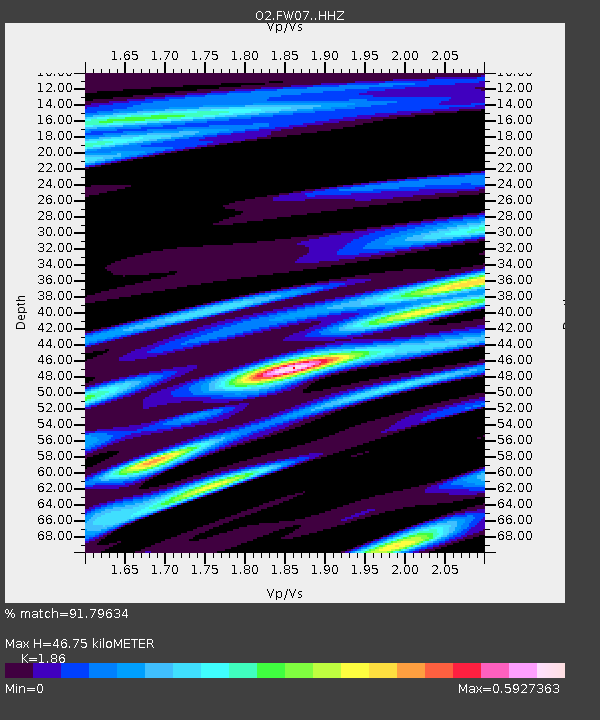
| Estimated Moho Depth: |
46.75 km |
| Estimated Crust Vp/Vs: |
1.86 |
| Assumed Crust Vp: |
6.426 km/s |
| Estimated Crust Vs: |
3.455 km/s |
| Estimated Crust Poisson's Ratio: |
0.30 |
|
| Radial Match: |
91.79634 % |
| Radial Bump: |
400 |
| Transverse Match: |
85.227104 % |
| Transverse Bump: |
400 |
| SOD ConfigId: |
29823551 |
| Insert Time: |
2022-12-18 20:46:09.383 +0000 |
| GWidth: |
2.5 |
| Max Bumps: |
400 |
| Tol: |
0.001 |
|

Signal To Noise
| Channel | StoN | STA | LTA |
| O2:FW07: :HHZ:20221204T19:36:24.56003Z | 15.161975 | 3.5705475E-6 | 2.3549357E-7 |
| O2:FW07: :HHN:20221204T19:36:24.56003Z | 1.0628866 | 2.7196467E-7 | 2.5587366E-7 |
| O2:FW07: :HHE:20221204T19:36:24.56003Z | 5.1172695 | 1.59136E-6 | 3.1097835E-7 |
| Arrivals |
| Ps | 6.4 SECOND |
| PpPs | 20 SECOND |
| PsPs/PpSs | 27 SECOND |


