You are here: Home > Network List > O2 - Oklahoma Consolidated Temporary Seismic Networks Stations List
> Station KS13 South Haven SW Station, Kansas > Earthquake Result Viewer
KS13 South Haven SW Station, Kansas - Earthquake Result Viewer
| Earthquake location: |
Samoa Islands Region |
| Earthquake latitude/longitude: |
-15.4/-173.0 |
| Earthquake time(UTC): |
2022/12/04 (338) 19:24:15 GMT |
| Earthquake Depth: |
36 km |
| Earthquake Magnitude: |
6.7 Mww |
| Earthquake Catalog/Contributor: |
NEIC PDE/us |
|
| Network: |
O2 Oklahoma Consolidated Temporary Seismic Networks |
| Station: |
KS13 South Haven SW Station, Kansas |
| Lat/Lon: |
37.01 N/97.48 W |
| Elevation: |
340 m |
|
| Distance: |
88.0 deg |
| Az: |
50.84 deg |
| Baz: |
249.127 deg |
| Ray Param: |
0.042881627 |
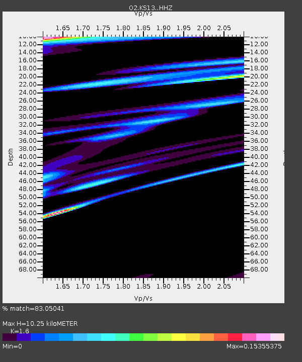
| Estimated Moho Depth: |
10.25 km |
| Estimated Crust Vp/Vs: |
1.60 |
| Assumed Crust Vp: |
6.483 km/s |
| Estimated Crust Vs: |
4.052 km/s |
| Estimated Crust Poisson's Ratio: |
0.18 |
|
| Radial Match: |
83.05041 % |
| Radial Bump: |
400 |
| Transverse Match: |
82.99006 % |
| Transverse Bump: |
400 |
| SOD ConfigId: |
29823551 |
| Insert Time: |
2022-12-18 20:46:19.205 +0000 |
| GWidth: |
2.5 |
| Max Bumps: |
400 |
| Tol: |
0.001 |
|

Signal To Noise
| Channel | StoN | STA | LTA |
| O2:KS13: :HHZ:20221204T19:36:30.300021Z | 7.8335857 | 2.7422298E-6 | 3.5006062E-7 |
| O2:KS13: :HHN:20221204T19:36:30.300021Z | 1.7499807 | 9.462926E-9 | 5.407446E-9 |
| O2:KS13: :HHE:20221204T19:36:30.300021Z | 0.77387965 | 7.149381E-7 | 9.238363E-7 |
| Arrivals |
| Ps | 1.0 SECOND |
| PpPs | 4.0 SECOND |
| PsPs/PpSs | 5.0 SECOND |


