You are here: Home > Network List > O2 - Oklahoma Consolidated Temporary Seismic Networks Stations List
> Station PW19 Marland, Oklahoma, USA > Earthquake Result Viewer
PW19 Marland, Oklahoma, USA - Earthquake Result Viewer
| Earthquake location: |
Samoa Islands Region |
| Earthquake latitude/longitude: |
-15.4/-173.0 |
| Earthquake time(UTC): |
2022/12/04 (338) 19:24:15 GMT |
| Earthquake Depth: |
36 km |
| Earthquake Magnitude: |
6.7 Mww |
| Earthquake Catalog/Contributor: |
NEIC PDE/us |
|
| Network: |
O2 Oklahoma Consolidated Temporary Seismic Networks |
| Station: |
PW19 Marland, Oklahoma, USA |
| Lat/Lon: |
36.57 N/97.04 W |
| Elevation: |
301 m |
|
| Distance: |
88.2 deg |
| Az: |
51.381 deg |
| Baz: |
249.409 deg |
| Ray Param: |
0.0427513 |
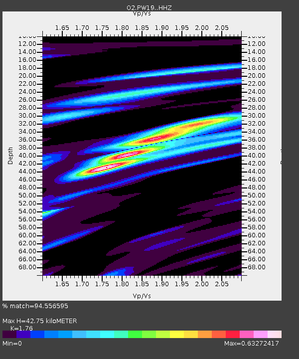
| Estimated Moho Depth: |
42.75 km |
| Estimated Crust Vp/Vs: |
1.76 |
| Assumed Crust Vp: |
6.483 km/s |
| Estimated Crust Vs: |
3.683 km/s |
| Estimated Crust Poisson's Ratio: |
0.26 |
|
| Radial Match: |
94.556595 % |
| Radial Bump: |
388 |
| Transverse Match: |
77.53812 % |
| Transverse Bump: |
400 |
| SOD ConfigId: |
29823551 |
| Insert Time: |
2022-12-18 20:46:41.177 +0000 |
| GWidth: |
2.5 |
| Max Bumps: |
400 |
| Tol: |
0.001 |
|

Signal To Noise
| Channel | StoN | STA | LTA |
| O2:PW19: :HHZ:20221204T19:36:31.129977Z | 12.13785 | 2.828415E-6 | 2.330244E-7 |
| O2:PW19: :HHN:20221204T19:36:31.129977Z | 2.5050833 | 5.9731474E-7 | 2.3844106E-7 |
| O2:PW19: :HHE:20221204T19:36:31.129977Z | 5.066048 | 9.793538E-7 | 1.933171E-7 |
| Arrivals |
| Ps | 5.1 SECOND |
| PpPs | 18 SECOND |
| PsPs/PpSs | 23 SECOND |


