You are here: Home > Network List > O2 - Oklahoma Consolidated Temporary Seismic Networks Stations List
> Station SC13 Stratford, Oklahoma, USA > Earthquake Result Viewer
SC13 Stratford, Oklahoma, USA - Earthquake Result Viewer
| Earthquake location: |
Samoa Islands Region |
| Earthquake latitude/longitude: |
-15.4/-173.0 |
| Earthquake time(UTC): |
2022/12/04 (338) 19:24:15 GMT |
| Earthquake Depth: |
36 km |
| Earthquake Magnitude: |
6.7 Mww |
| Earthquake Catalog/Contributor: |
NEIC PDE/us |
|
| Network: |
O2 Oklahoma Consolidated Temporary Seismic Networks |
| Station: |
SC13 Stratford, Oklahoma, USA |
| Lat/Lon: |
34.73 N/96.95 W |
| Elevation: |
363 m |
|
| Distance: |
87.6 deg |
| Az: |
53.128 deg |
| Baz: |
249.526 deg |
| Ray Param: |
0.043177035 |
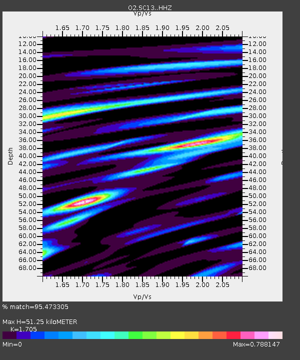
| Estimated Moho Depth: |
51.25 km |
| Estimated Crust Vp/Vs: |
1.71 |
| Assumed Crust Vp: |
6.426 km/s |
| Estimated Crust Vs: |
3.769 km/s |
| Estimated Crust Poisson's Ratio: |
0.24 |
|
| Radial Match: |
95.473305 % |
| Radial Bump: |
343 |
| Transverse Match: |
83.37587 % |
| Transverse Bump: |
400 |
| SOD ConfigId: |
29823551 |
| Insert Time: |
2022-12-18 20:47:09.141 +0000 |
| GWidth: |
2.5 |
| Max Bumps: |
400 |
| Tol: |
0.001 |
|

Signal To Noise
| Channel | StoN | STA | LTA |
| O2:SC13: :HHZ:20221204T19:36:28.389986Z | 24.496712 | 3.7287891E-6 | 1.522159E-7 |
| O2:SC13: :HHN:20221204T19:36:28.389986Z | 3.0611632 | 9.678495E-7 | 3.1617046E-7 |
| O2:SC13: :HHE:20221204T19:36:28.389986Z | 3.2141943 | 1.0284396E-6 | 3.1996805E-7 |
| Arrivals |
| Ps | 5.8 SECOND |
| PpPs | 21 SECOND |
| PsPs/PpSs | 27 SECOND |


