You are here: Home > Network List > O2 - Oklahoma Consolidated Temporary Seismic Networks Stations List
> Station TUTT Tuttle, Oklahoma, USA > Earthquake Result Viewer
TUTT Tuttle, Oklahoma, USA - Earthquake Result Viewer
| Earthquake location: |
Samoa Islands Region |
| Earthquake latitude/longitude: |
-15.4/-173.0 |
| Earthquake time(UTC): |
2022/12/04 (338) 19:24:15 GMT |
| Earthquake Depth: |
36 km |
| Earthquake Magnitude: |
6.7 Mww |
| Earthquake Catalog/Contributor: |
NEIC PDE/us |
|
| Network: |
O2 Oklahoma Consolidated Temporary Seismic Networks |
| Station: |
TUTT Tuttle, Oklahoma, USA |
| Lat/Lon: |
35.24 N/97.76 W |
| Elevation: |
407 m |
|
| Distance: |
87.1 deg |
| Az: |
52.416 deg |
| Baz: |
249.031 deg |
| Ray Param: |
0.043493636 |
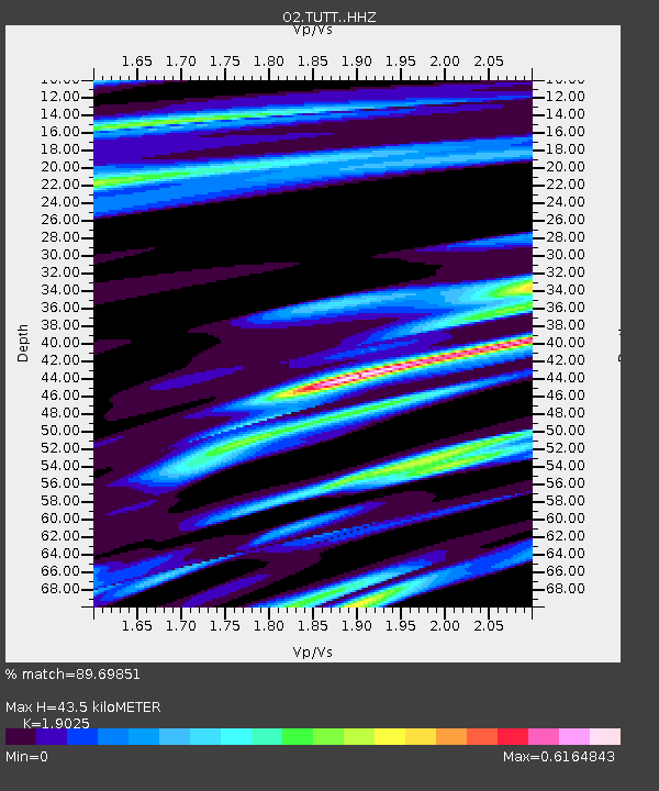
| Estimated Moho Depth: |
43.5 km |
| Estimated Crust Vp/Vs: |
1.90 |
| Assumed Crust Vp: |
6.426 km/s |
| Estimated Crust Vs: |
3.378 km/s |
| Estimated Crust Poisson's Ratio: |
0.31 |
|
| Radial Match: |
89.69851 % |
| Radial Bump: |
400 |
| Transverse Match: |
71.62094 % |
| Transverse Bump: |
400 |
| SOD ConfigId: |
29823551 |
| Insert Time: |
2022-12-18 20:47:27.101 +0000 |
| GWidth: |
2.5 |
| Max Bumps: |
400 |
| Tol: |
0.001 |
|

Signal To Noise
| Channel | StoN | STA | LTA |
| O2:TUTT: :HHZ:20221204T19:36:26.259981Z | 15.788574 | 4.224236E-6 | 2.6755018E-7 |
| O2:TUTT: :HHN:20221204T19:36:26.259981Z | 1.1740768 | 5.128833E-7 | 4.3683966E-7 |
| O2:TUTT: :HHE:20221204T19:36:26.259981Z | 4.946279 | 1.7268367E-6 | 3.4911835E-7 |
| Arrivals |
| Ps | 6.2 SECOND |
| PpPs | 19 SECOND |
| PsPs/PpSs | 25 SECOND |


