You are here: Home > Network List > RV - Regional Alberta Seismic Observatory for Earthquake Studies Network Stations List
> Station BRLDA Berland Lookout Tower, AB > Earthquake Result Viewer
BRLDA Berland Lookout Tower, AB - Earthquake Result Viewer
| Earthquake location: |
Samoa Islands Region |
| Earthquake latitude/longitude: |
-15.4/-173.0 |
| Earthquake time(UTC): |
2022/12/04 (338) 19:24:15 GMT |
| Earthquake Depth: |
36 km |
| Earthquake Magnitude: |
6.7 Mww |
| Earthquake Catalog/Contributor: |
NEIC PDE/us |
|
| Network: |
RV Regional Alberta Seismic Observatory for Earthquake Studies Network |
| Station: |
BRLDA Berland Lookout Tower, AB |
| Lat/Lon: |
54.09 N/117.40 W |
| Elevation: |
1224 m |
|
| Distance: |
83.8 deg |
| Az: |
29.256 deg |
| Baz: |
233.151 deg |
| Ray Param: |
0.045884132 |
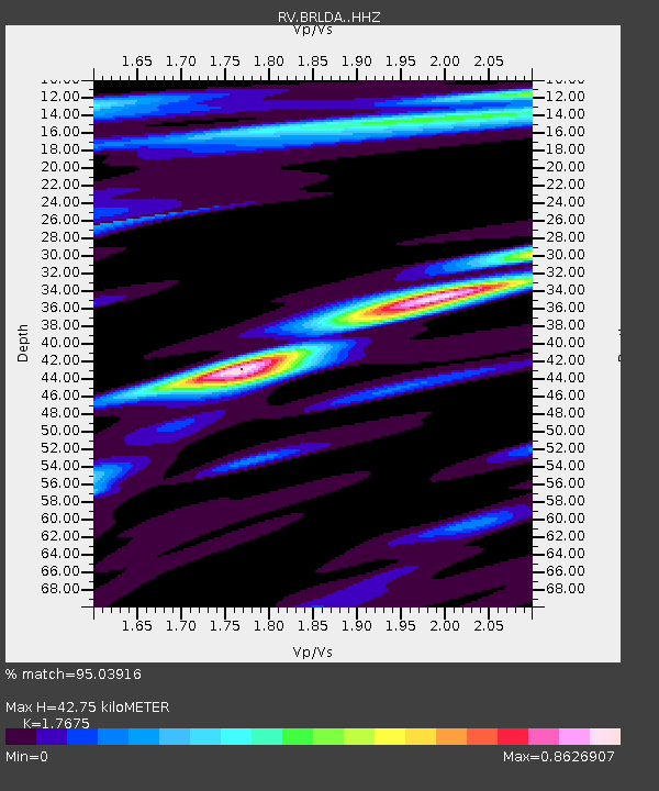
| Estimated Moho Depth: |
42.75 km |
| Estimated Crust Vp/Vs: |
1.77 |
| Assumed Crust Vp: |
6.426 km/s |
| Estimated Crust Vs: |
3.636 km/s |
| Estimated Crust Poisson's Ratio: |
0.26 |
|
| Radial Match: |
95.03916 % |
| Radial Bump: |
400 |
| Transverse Match: |
85.66134 % |
| Transverse Bump: |
400 |
| SOD ConfigId: |
29823551 |
| Insert Time: |
2022-12-18 20:50:05.158 +0000 |
| GWidth: |
2.5 |
| Max Bumps: |
400 |
| Tol: |
0.001 |
|

Signal To Noise
| Channel | StoN | STA | LTA |
| RV:BRLDA: :HHZ:20221204T19:36:09.699984Z | 11.725596 | 5.2001096E-6 | 4.4348363E-7 |
| RV:BRLDA: :HHN:20221204T19:36:09.699984Z | 4.4857955 | 1.6692188E-6 | 3.721121E-7 |
| RV:BRLDA: :HHE:20221204T19:36:09.699984Z | 4.23438 | 1.3701602E-6 | 3.235799E-7 |
| Arrivals |
| Ps | 5.2 SECOND |
| PpPs | 18 SECOND |
| PsPs/PpSs | 23 SECOND |


