You are here: Home > Network List > RV - Regional Alberta Seismic Observatory for Earthquake Studies Network Stations List
> Station LGPLA Lodgepole, AB > Earthquake Result Viewer
LGPLA Lodgepole, AB - Earthquake Result Viewer
| Earthquake location: |
Samoa Islands Region |
| Earthquake latitude/longitude: |
-15.4/-173.0 |
| Earthquake time(UTC): |
2022/12/04 (338) 19:24:15 GMT |
| Earthquake Depth: |
36 km |
| Earthquake Magnitude: |
6.7 Mww |
| Earthquake Catalog/Contributor: |
NEIC PDE/us |
|
| Network: |
RV Regional Alberta Seismic Observatory for Earthquake Studies Network |
| Station: |
LGPLA Lodgepole, AB |
| Lat/Lon: |
53.11 N/115.36 W |
| Elevation: |
886 m |
|
| Distance: |
84.2 deg |
| Az: |
30.773 deg |
| Baz: |
234.955 deg |
| Ray Param: |
0.045595825 |
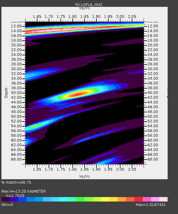
| Estimated Moho Depth: |
13.25 km |
| Estimated Crust Vp/Vs: |
1.75 |
| Assumed Crust Vp: |
6.426 km/s |
| Estimated Crust Vs: |
3.667 km/s |
| Estimated Crust Poisson's Ratio: |
0.26 |
|
| Radial Match: |
88.75 % |
| Radial Bump: |
400 |
| Transverse Match: |
80.529205 % |
| Transverse Bump: |
400 |
| SOD ConfigId: |
29823551 |
| Insert Time: |
2022-12-18 20:50:17.198 +0000 |
| GWidth: |
2.5 |
| Max Bumps: |
400 |
| Tol: |
0.001 |
|

Signal To Noise
| Channel | StoN | STA | LTA |
| RV:LGPLA: :HHZ:20221204T19:36:11.800021Z | 8.692095 | 3.385223E-6 | 3.8945996E-7 |
| RV:LGPLA: :HHN:20221204T19:36:11.800021Z | 1.3152856 | 5.2048125E-7 | 3.9571728E-7 |
| RV:LGPLA: :HHE:20221204T19:36:11.800021Z | 2.4995348 | 1.3812968E-6 | 5.5262154E-7 |
| Arrivals |
| Ps | 1.6 SECOND |
| PpPs | 5.5 SECOND |
| PsPs/PpSs | 7.1 SECOND |


