You are here: Home > Network List > RV - Regional Alberta Seismic Observatory for Earthquake Studies Network Stations List
> Station PECRA Peace River, AB > Earthquake Result Viewer
PECRA Peace River, AB - Earthquake Result Viewer
| Earthquake location: |
Samoa Islands Region |
| Earthquake latitude/longitude: |
-15.4/-173.0 |
| Earthquake time(UTC): |
2022/12/04 (338) 19:24:15 GMT |
| Earthquake Depth: |
36 km |
| Earthquake Magnitude: |
6.7 Mww |
| Earthquake Catalog/Contributor: |
NEIC PDE/us |
|
| Network: |
RV Regional Alberta Seismic Observatory for Earthquake Studies Network |
| Station: |
PECRA Peace River, AB |
| Lat/Lon: |
56.30 N/117.03 W |
| Elevation: |
592 m |
|
| Distance: |
85.3 deg |
| Az: |
27.608 deg |
| Baz: |
233.303 deg |
| Ray Param: |
0.044820525 |
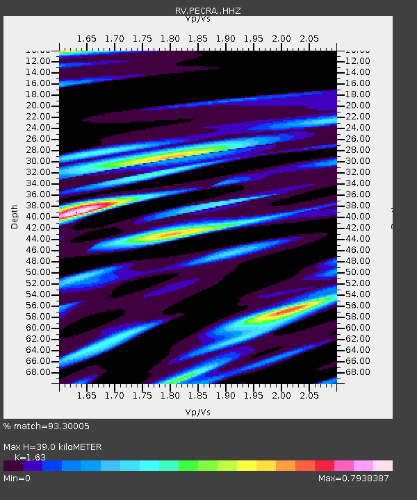
| Estimated Moho Depth: |
39.0 km |
| Estimated Crust Vp/Vs: |
1.63 |
| Assumed Crust Vp: |
6.444 km/s |
| Estimated Crust Vs: |
3.953 km/s |
| Estimated Crust Poisson's Ratio: |
0.20 |
|
| Radial Match: |
93.30005 % |
| Radial Bump: |
400 |
| Transverse Match: |
75.408356 % |
| Transverse Bump: |
400 |
| SOD ConfigId: |
29823551 |
| Insert Time: |
2022-12-18 20:50:21.367 +0000 |
| GWidth: |
2.5 |
| Max Bumps: |
400 |
| Tol: |
0.001 |
|

Signal To Noise
| Channel | StoN | STA | LTA |
| RV:PECRA: :HHZ:20221204T19:36:17.220003Z | 12.16628 | 3.6647073E-6 | 3.012184E-7 |
| RV:PECRA: :HHN:20221204T19:36:17.220003Z | 3.779365 | 1.4445764E-6 | 3.8222723E-7 |
| RV:PECRA: :HHE:20221204T19:36:17.220003Z | 2.7408688 | 1.2937011E-6 | 4.7200402E-7 |
| Arrivals |
| Ps | 3.9 SECOND |
| PpPs | 16 SECOND |
| PsPs/PpSs | 19 SECOND |


