You are here: Home > Network List > RV - Regional Alberta Seismic Observatory for Earthquake Studies Network Stations List
> Station TONYA Tony Lookout Tower, AB > Earthquake Result Viewer
TONYA Tony Lookout Tower, AB - Earthquake Result Viewer
| Earthquake location: |
Samoa Islands Region |
| Earthquake latitude/longitude: |
-15.4/-173.0 |
| Earthquake time(UTC): |
2022/12/04 (338) 19:24:15 GMT |
| Earthquake Depth: |
36 km |
| Earthquake Magnitude: |
6.7 Mww |
| Earthquake Catalog/Contributor: |
NEIC PDE/us |
|
| Network: |
RV Regional Alberta Seismic Observatory for Earthquake Studies Network |
| Station: |
TONYA Tony Lookout Tower, AB |
| Lat/Lon: |
54.41 N/117.49 W |
| Elevation: |
1017 m |
|
| Distance: |
83.9 deg |
| Az: |
28.972 deg |
| Baz: |
233.05 deg |
| Ray Param: |
0.0457791 |
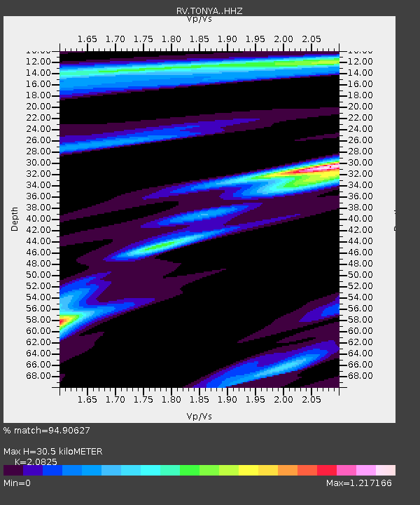
| Estimated Moho Depth: |
30.5 km |
| Estimated Crust Vp/Vs: |
2.08 |
| Assumed Crust Vp: |
6.426 km/s |
| Estimated Crust Vs: |
3.086 km/s |
| Estimated Crust Poisson's Ratio: |
0.35 |
|
| Radial Match: |
94.90627 % |
| Radial Bump: |
294 |
| Transverse Match: |
73.216515 % |
| Transverse Bump: |
400 |
| SOD ConfigId: |
29823551 |
| Insert Time: |
2022-12-18 20:50:31.582 +0000 |
| GWidth: |
2.5 |
| Max Bumps: |
400 |
| Tol: |
0.001 |
|

Signal To Noise
| Channel | StoN | STA | LTA |
| RV:TONYA: :HHZ:20221204T19:36:10.449984Z | 10.434892 | 4.653255E-6 | 4.4593227E-7 |
| RV:TONYA: :HHN:20221204T19:36:10.449984Z | 2.5235505 | 1.2798773E-6 | 5.0717324E-7 |
| RV:TONYA: :HHE:20221204T19:36:10.449984Z | 4.418169 | 1.4752699E-6 | 3.3390978E-7 |
| Arrivals |
| Ps | 5.2 SECOND |
| PpPs | 14 SECOND |
| PsPs/PpSs | 20 SECOND |


