You are here: Home > Network List > S1 - Australian Seismometers in Schools Stations List
> Station AUMHS Melrose High School > Earthquake Result Viewer
AUMHS Melrose High School - Earthquake Result Viewer
| Earthquake location: |
Samoa Islands Region |
| Earthquake latitude/longitude: |
-15.4/-173.0 |
| Earthquake time(UTC): |
2022/12/04 (338) 19:24:15 GMT |
| Earthquake Depth: |
36 km |
| Earthquake Magnitude: |
6.7 Mww |
| Earthquake Catalog/Contributor: |
NEIC PDE/us |
|
| Network: |
S1 Australian Seismometers in Schools |
| Station: |
AUMHS Melrose High School |
| Lat/Lon: |
35.36 S/149.09 E |
| Elevation: |
615 m |
|
| Distance: |
39.3 deg |
| Az: |
232.497 deg |
| Baz: |
69.427 deg |
| Ray Param: |
0.07499713 |
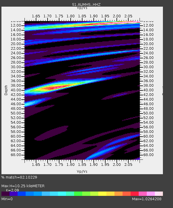
| Estimated Moho Depth: |
10.25 km |
| Estimated Crust Vp/Vs: |
2.09 |
| Assumed Crust Vp: |
6.633 km/s |
| Estimated Crust Vs: |
3.174 km/s |
| Estimated Crust Poisson's Ratio: |
0.35 |
|
| Radial Match: |
82.10229 % |
| Radial Bump: |
322 |
| Transverse Match: |
74.21522 % |
| Transverse Bump: |
400 |
| SOD ConfigId: |
29823551 |
| Insert Time: |
2022-12-18 20:51:13.631 +0000 |
| GWidth: |
2.5 |
| Max Bumps: |
400 |
| Tol: |
0.001 |
|

Signal To Noise
| Channel | StoN | STA | LTA |
| S1:AUMHS: :HHZ:20221204T19:31:10.359988Z | 7.8639174 | 2.8766542E-6 | 3.6580423E-7 |
| S1:AUMHS: :HHN:20221204T19:31:10.359988Z | 3.5256848 | 9.005122E-7 | 2.5541482E-7 |
| S1:AUMHS: :HHE:20221204T19:31:10.359988Z | 2.7319336 | 1.444199E-6 | 5.2863624E-7 |
| Arrivals |
| Ps | 1.8 SECOND |
| PpPs | 4.5 SECOND |
| PsPs/PpSs | 6.3 SECOND |


