You are here: Home > Network List > TM - Thai Seismic Monitoring Network Stations List
> Station SKLT Mueang, Songkhla > Earthquake Result Viewer
SKLT Mueang, Songkhla - Earthquake Result Viewer
| Earthquake location: |
Samoa Islands Region |
| Earthquake latitude/longitude: |
-15.4/-173.0 |
| Earthquake time(UTC): |
2022/12/04 (338) 19:24:15 GMT |
| Earthquake Depth: |
36 km |
| Earthquake Magnitude: |
6.7 Mww |
| Earthquake Catalog/Contributor: |
NEIC PDE/us |
|
| Network: |
TM Thai Seismic Monitoring Network |
| Station: |
SKLT Mueang, Songkhla |
| Lat/Lon: |
7.18 N/100.62 E |
| Elevation: |
11 m |
|
| Distance: |
88.4 deg |
| Az: |
277.823 deg |
| Baz: |
105.629 deg |
| Ray Param: |
0.042530883 |
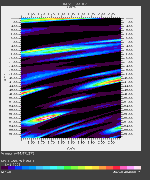
| Estimated Moho Depth: |
59.75 km |
| Estimated Crust Vp/Vs: |
1.72 |
| Assumed Crust Vp: |
6.468 km/s |
| Estimated Crust Vs: |
3.755 km/s |
| Estimated Crust Poisson's Ratio: |
0.25 |
|
| Radial Match: |
94.971275 % |
| Radial Bump: |
291 |
| Transverse Match: |
86.07676 % |
| Transverse Bump: |
400 |
| SOD ConfigId: |
29823551 |
| Insert Time: |
2022-12-18 20:52:55.655 +0000 |
| GWidth: |
2.5 |
| Max Bumps: |
400 |
| Tol: |
0.001 |
|

Signal To Noise
| Channel | StoN | STA | LTA |
| TM:SKLT:00:HHZ:20221204T19:36:32.524996Z | 1.9736506 | 3.0539434E-7 | 1.5473576E-7 |
| TM:SKLT:00:HHN:20221204T19:36:32.524996Z | 1.1361438 | 1.7167419E-7 | 1.5110253E-7 |
| TM:SKLT:00:HHE:20221204T19:36:32.524996Z | 0.94995904 | 1.722235E-7 | 1.812957E-7 |
| Arrivals |
| Ps | 6.8 SECOND |
| PpPs | 25 SECOND |
| PsPs/PpSs | 31 SECOND |


