You are here: Home > Network List > TX - Texas Seismological Network Stations List
> Station PB04 Verhalen > Earthquake Result Viewer
PB04 Verhalen - Earthquake Result Viewer
| Earthquake location: |
Samoa Islands Region |
| Earthquake latitude/longitude: |
-15.4/-173.0 |
| Earthquake time(UTC): |
2022/12/04 (338) 19:24:15 GMT |
| Earthquake Depth: |
36 km |
| Earthquake Magnitude: |
6.7 Mww |
| Earthquake Catalog/Contributor: |
NEIC PDE/us |
|
| Network: |
TX Texas Seismological Network |
| Station: |
PB04 Verhalen |
| Lat/Lon: |
31.19 N/103.27 W |
| Elevation: |
812 m |
|
| Distance: |
81.3 deg |
| Az: |
54.398 deg |
| Baz: |
246.221 deg |
| Ray Param: |
0.04762137 |
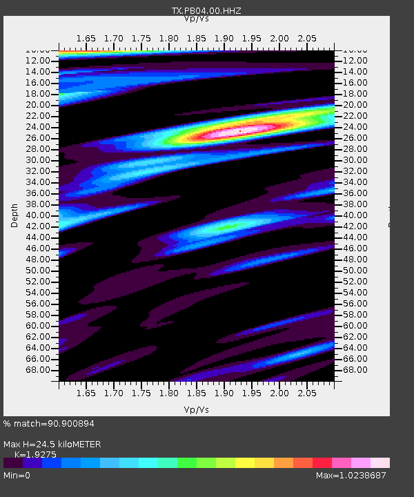
| Estimated Moho Depth: |
24.5 km |
| Estimated Crust Vp/Vs: |
1.93 |
| Assumed Crust Vp: |
6.121 km/s |
| Estimated Crust Vs: |
3.175 km/s |
| Estimated Crust Poisson's Ratio: |
0.32 |
|
| Radial Match: |
90.900894 % |
| Radial Bump: |
400 |
| Transverse Match: |
88.92664 % |
| Transverse Bump: |
400 |
| SOD ConfigId: |
29823551 |
| Insert Time: |
2022-12-18 20:53:57.174 +0000 |
| GWidth: |
2.5 |
| Max Bumps: |
400 |
| Tol: |
0.001 |
|

Signal To Noise
| Channel | StoN | STA | LTA |
| TX:PB04:00:HHZ:20221204T19:35:56.879977Z | 10.083366 | 3.3884082E-6 | 3.3603936E-7 |
| TX:PB04:00:HH1:20221204T19:35:56.879977Z | 3.232426 | 4.0239482E-7 | 1.2448693E-7 |
| TX:PB04:00:HH2:20221204T19:35:56.879977Z | 4.1148086 | 7.4782946E-7 | 1.81741E-7 |
| Arrivals |
| Ps | 3.8 SECOND |
| PpPs | 11 SECOND |
| PsPs/PpSs | 15 SECOND |


