You are here: Home > Network List > TX - Texas Seismological Network Stations List
> Station PB16 Coyonosa > Earthquake Result Viewer
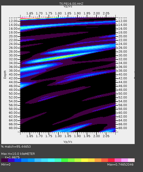
PB16 Coyonosa - Earthquake Result Viewer
| Earthquake location: |
Samoa Islands Region |
| Earthquake latitude/longitude: |
-15.4/-173.0 |
| Earthquake time(UTC): |
2022/12/04 (338) 19:24:15 GMT |
| Earthquake Depth: |
36 km |
| Earthquake Magnitude: |
6.7 Mww |
| Earthquake Catalog/Contributor: |
NEIC PDE/us |
|
| Network: |
TX Texas Seismological Network |
| Station: |
PB16 Coyonosa |
| Lat/Lon: |
31.12 N/103.25 W |
| Elevation: |
848 m |
|
| Distance: |
81.3 deg |
| Az: |
54.461 deg |
| Baz: |
246.24 deg |
| Ray Param: |
0.04762929 |
| Estimated Moho Depth: |
10.0 km |
| Estimated Crust Vp/Vs: |
1.67 |
| Assumed Crust Vp: |
6.121 km/s |
| Estimated Crust Vs: |
3.67 km/s |
| Estimated Crust Poisson's Ratio: |
0.22 |
|
| Radial Match: |
95.44653 % |
| Radial Bump: |
400 |
| Transverse Match: |
88.20577 % |
| Transverse Bump: |
400 |
| SOD ConfigId: |
29823551 |
| Insert Time: |
2022-12-18 20:54:14.194 +0000 |
| GWidth: |
2.5 |
| Max Bumps: |
400 |
| Tol: |
0.001 |
|

Signal To Noise
| Channel | StoN | STA | LTA |
| TX:PB16:00:HHZ:20221204T19:35:56.819979Z | 10.896597 | 3.3822016E-6 | 3.1039065E-7 |
| TX:PB16:00:HH1:20221204T19:35:56.819979Z | 0.68877274 | 2.0084754E-7 | 2.9160205E-7 |
| TX:PB16:00:HH2:20221204T19:35:56.819979Z | 5.9433756 | 9.525617E-7 | 1.6027285E-7 |
| Arrivals |
| Ps | 1.1 SECOND |
| PpPs | 4.2 SECOND |
| PsPs/PpSs | 5.4 SECOND |


