You are here: Home > Network List > TX - Texas Seismological Network Stations List
> Station PB22 South of Coyonosa > Earthquake Result Viewer
PB22 South of Coyonosa - Earthquake Result Viewer
| Earthquake location: |
Samoa Islands Region |
| Earthquake latitude/longitude: |
-15.4/-173.0 |
| Earthquake time(UTC): |
2022/12/04 (338) 19:24:15 GMT |
| Earthquake Depth: |
36 km |
| Earthquake Magnitude: |
6.7 Mww |
| Earthquake Catalog/Contributor: |
NEIC PDE/us |
|
| Network: |
TX Texas Seismological Network |
| Station: |
PB22 South of Coyonosa |
| Lat/Lon: |
31.21 N/103.08 W |
| Elevation: |
808 m |
|
| Distance: |
81.5 deg |
| Az: |
54.442 deg |
| Baz: |
246.327 deg |
| Ray Param: |
0.047508076 |
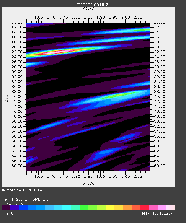
| Estimated Moho Depth: |
21.75 km |
| Estimated Crust Vp/Vs: |
1.73 |
| Assumed Crust Vp: |
6.121 km/s |
| Estimated Crust Vs: |
3.548 km/s |
| Estimated Crust Poisson's Ratio: |
0.25 |
|
| Radial Match: |
92.269714 % |
| Radial Bump: |
400 |
| Transverse Match: |
73.753006 % |
| Transverse Bump: |
400 |
| SOD ConfigId: |
29823551 |
| Insert Time: |
2022-12-18 20:54:21.191 +0000 |
| GWidth: |
2.5 |
| Max Bumps: |
400 |
| Tol: |
0.001 |
|

Signal To Noise
| Channel | StoN | STA | LTA |
| TX:PB22:00:HHZ:20221204T19:35:57.725008Z | 22.440203 | 5.0413695E-7 | 2.2465793E-8 |
| TX:PB22:00:HH1:20221204T19:35:57.725008Z | 4.9444714 | 1.1239306E-7 | 2.2731056E-8 |
| TX:PB22:00:HH2:20221204T19:35:57.725008Z | 5.1817636 | 1.1343433E-7 | 2.1891067E-8 |
| Arrivals |
| Ps | 2.6 SECOND |
| PpPs | 9.4 SECOND |
| PsPs/PpSs | 12 SECOND |


