You are here: Home > Network List > UO - University of Oregon Regional Network Stations List
> Station HBUG Ophir, OR, USA > Earthquake Result Viewer
HBUG Ophir, OR, USA - Earthquake Result Viewer
| Earthquake location: |
Samoa Islands Region |
| Earthquake latitude/longitude: |
-15.4/-173.0 |
| Earthquake time(UTC): |
2022/12/04 (338) 19:24:15 GMT |
| Earthquake Depth: |
36 km |
| Earthquake Magnitude: |
6.7 Mww |
| Earthquake Catalog/Contributor: |
NEIC PDE/us |
|
| Network: |
UO University of Oregon Regional Network |
| Station: |
HBUG Ophir, OR, USA |
| Lat/Lon: |
42.64 N/124.38 W |
| Elevation: |
388 m |
|
| Distance: |
73.0 deg |
| Az: |
35.362 deg |
| Baz: |
229.159 deg |
| Ray Param: |
0.05325631 |
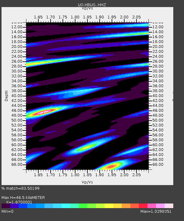
| Estimated Moho Depth: |
46.5 km |
| Estimated Crust Vp/Vs: |
1.67 |
| Assumed Crust Vp: |
6.048 km/s |
| Estimated Crust Vs: |
3.622 km/s |
| Estimated Crust Poisson's Ratio: |
0.22 |
|
| Radial Match: |
83.50199 % |
| Radial Bump: |
400 |
| Transverse Match: |
73.20852 % |
| Transverse Bump: |
400 |
| SOD ConfigId: |
29823551 |
| Insert Time: |
2022-12-18 20:55:27.312 +0000 |
| GWidth: |
2.5 |
| Max Bumps: |
400 |
| Tol: |
0.001 |
|

Signal To Noise
| Channel | StoN | STA | LTA |
| UO:HBUG: :HHZ:20221204T19:35:10.230013Z | 5.5260973 | 4.68881E-6 | 8.4848483E-7 |
| UO:HBUG: :HHN:20221204T19:35:10.230013Z | 1.6053466 | 1.269768E-6 | 7.9096185E-7 |
| UO:HBUG: :HHE:20221204T19:35:10.230013Z | 1.3346169 | 1.467998E-6 | 1.0999396E-6 |
| Arrivals |
| Ps | 5.3 SECOND |
| PpPs | 20 SECOND |
| PsPs/PpSs | 25 SECOND |


