You are here: Home > Network List > UO - University of Oregon Regional Network Stations List
> Station LONE Glide, OR, USA > Earthquake Result Viewer
LONE Glide, OR, USA - Earthquake Result Viewer
| Earthquake location: |
Samoa Islands Region |
| Earthquake latitude/longitude: |
-15.4/-173.0 |
| Earthquake time(UTC): |
2022/12/04 (338) 19:24:15 GMT |
| Earthquake Depth: |
36 km |
| Earthquake Magnitude: |
6.7 Mww |
| Earthquake Catalog/Contributor: |
NEIC PDE/us |
|
| Network: |
UO University of Oregon Regional Network |
| Station: |
LONE Glide, OR, USA |
| Lat/Lon: |
43.36 N/123.06 W |
| Elevation: |
1226 m |
|
| Distance: |
74.2 deg |
| Az: |
35.443 deg |
| Baz: |
230.08 deg |
| Ray Param: |
0.052459404 |
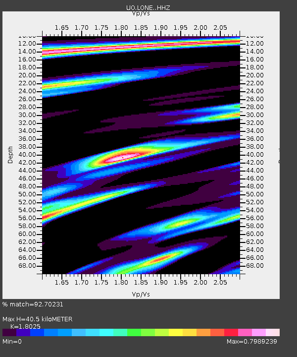
| Estimated Moho Depth: |
40.5 km |
| Estimated Crust Vp/Vs: |
1.80 |
| Assumed Crust Vp: |
6.522 km/s |
| Estimated Crust Vs: |
3.618 km/s |
| Estimated Crust Poisson's Ratio: |
0.28 |
|
| Radial Match: |
92.70231 % |
| Radial Bump: |
361 |
| Transverse Match: |
79.85543 % |
| Transverse Bump: |
400 |
| SOD ConfigId: |
29823551 |
| Insert Time: |
2022-12-18 20:55:45.289 +0000 |
| GWidth: |
2.5 |
| Max Bumps: |
400 |
| Tol: |
0.001 |
|

Signal To Noise
| Channel | StoN | STA | LTA |
| UO:LONE: :HHZ:20221204T19:35:17.290011Z | 12.422607 | 5.452495E-6 | 4.3891708E-7 |
| UO:LONE: :HHN:20221204T19:35:17.290011Z | 1.5528845 | 1.2248655E-6 | 7.88768E-7 |
| UO:LONE: :HHE:20221204T19:35:17.290011Z | 2.2395093 | 1.570332E-6 | 7.0119466E-7 |
| Arrivals |
| Ps | 5.2 SECOND |
| PpPs | 17 SECOND |
| PsPs/PpSs | 22 SECOND |


