You are here: Home > Network List > UO - University of Oregon Regional Network Stations List
> Station NBFR Nehalem, OR, USA > Earthquake Result Viewer
NBFR Nehalem, OR, USA - Earthquake Result Viewer
| Earthquake location: |
Samoa Islands Region |
| Earthquake latitude/longitude: |
-15.4/-173.0 |
| Earthquake time(UTC): |
2022/12/04 (338) 19:24:15 GMT |
| Earthquake Depth: |
36 km |
| Earthquake Magnitude: |
6.7 Mww |
| Earthquake Catalog/Contributor: |
NEIC PDE/us |
|
| Network: |
UO University of Oregon Regional Network |
| Station: |
NBFR Nehalem, OR, USA |
| Lat/Lon: |
45.73 N/123.85 W |
| Elevation: |
12 m |
|
| Distance: |
75.3 deg |
| Az: |
33.198 deg |
| Baz: |
228.933 deg |
| Ray Param: |
0.0517199 |
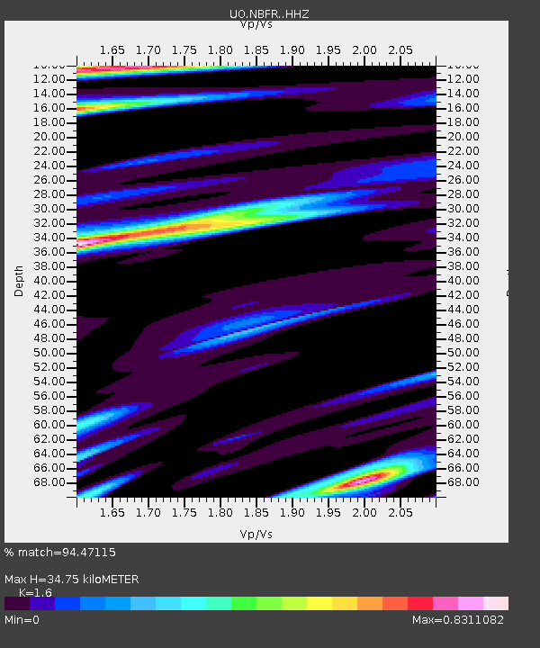
| Estimated Moho Depth: |
34.75 km |
| Estimated Crust Vp/Vs: |
1.60 |
| Assumed Crust Vp: |
6.566 km/s |
| Estimated Crust Vs: |
4.104 km/s |
| Estimated Crust Poisson's Ratio: |
0.18 |
|
| Radial Match: |
94.47115 % |
| Radial Bump: |
400 |
| Transverse Match: |
84.77574 % |
| Transverse Bump: |
400 |
| SOD ConfigId: |
29823551 |
| Insert Time: |
2022-12-18 20:55:57.094 +0000 |
| GWidth: |
2.5 |
| Max Bumps: |
400 |
| Tol: |
0.001 |
|

Signal To Noise
| Channel | StoN | STA | LTA |
| UO:NBFR: :HHZ:20221204T19:35:23.649996Z | 7.9291544 | 4.0163154E-6 | 5.0652505E-7 |
| UO:NBFR: :HHN:20221204T19:35:23.649996Z | 2.051025 | 1.3475819E-6 | 6.570286E-7 |
| UO:NBFR: :HHE:20221204T19:35:23.649996Z | 2.394447 | 1.5377301E-6 | 6.4220677E-7 |
| Arrivals |
| Ps | 3.3 SECOND |
| PpPs | 13 SECOND |
| PsPs/PpSs | 17 SECOND |


