You are here: Home > Network List > US - United States National Seismic Network Stations List
> Station EGMT Eagleton, Montana, USA > Earthquake Result Viewer
EGMT Eagleton, Montana, USA - Earthquake Result Viewer

| Earthquake location: |
Samoa Islands Region |
| Earthquake latitude/longitude: |
-15.4/-173.0 |
| Earthquake time(UTC): |
2022/12/04 (338) 19:24:15 GMT |
| Earthquake Depth: |
36 km |
| Earthquake Magnitude: |
6.7 Mww |
| Earthquake Catalog/Contributor: |
NEIC PDE/us |
|
| Network: |
US United States National Seismic Network |
| Station: |
EGMT Eagleton, Montana, USA |
| Lat/Lon: |
48.02 N/109.75 W |
| Elevation: |
1055 m |
|
| Distance: |
84.5 deg |
| Az: |
37.017 deg |
| Baz: |
239.89 deg |
| Ray Param: |
0.04540885 |
| Estimated Moho Depth: |
46.25 km |
| Estimated Crust Vp/Vs: |
1.67 |
| Assumed Crust Vp: |
6.438 km/s |
| Estimated Crust Vs: |
3.855 km/s |
| Estimated Crust Poisson's Ratio: |
0.22 |
|
| Radial Match: |
93.35462 % |
| Radial Bump: |
400 |
| Transverse Match: |
87.294106 % |
| Transverse Bump: |
400 |
| SOD ConfigId: |
29823551 |
| Insert Time: |
2022-12-18 20:57:03.432 +0000 |
| GWidth: |
2.5 |
| Max Bumps: |
400 |
| Tol: |
0.001 |
|
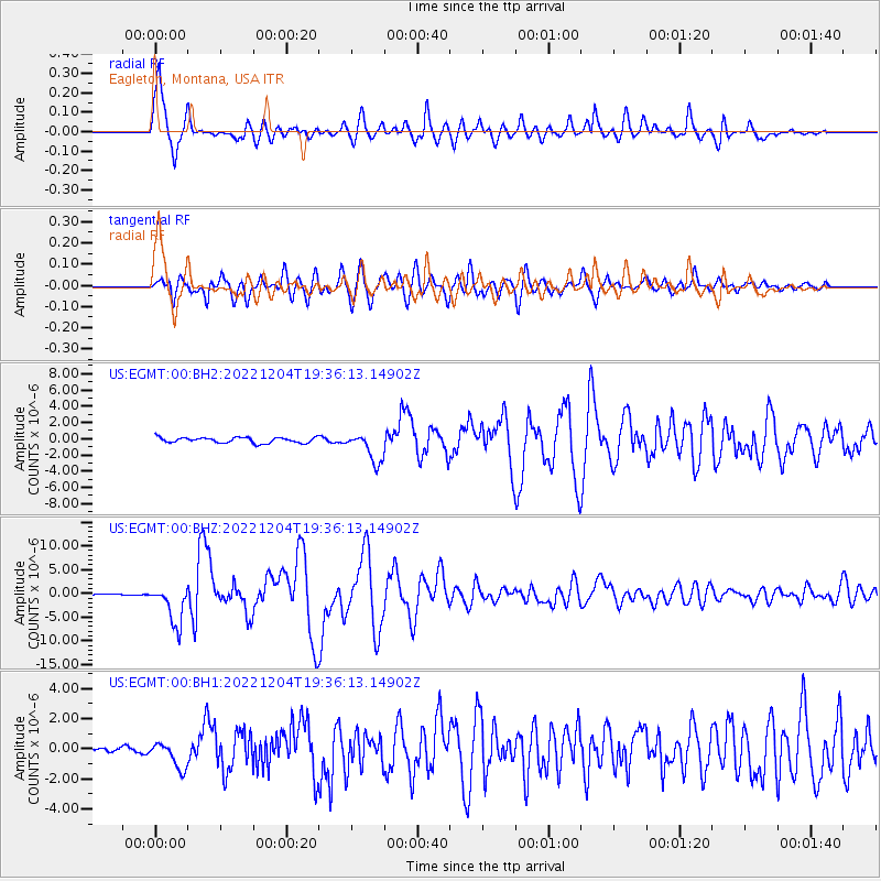
Signal To Noise
| Channel | StoN | STA | LTA |
| US:EGMT:00:BHZ:20221204T19:36:13.14902Z | 20.905317 | 4.19177E-6 | 2.0051215E-7 |
| US:EGMT:00:BH1:20221204T19:36:13.14902Z | 3.4119902 | 8.814518E-7 | 2.583395E-7 |
| US:EGMT:00:BH2:20221204T19:36:13.14902Z | 5.4603076 | 1.829291E-6 | 3.350161E-7 |
| Arrivals |
| Ps | 4.9 SECOND |
| PpPs | 19 SECOND |
| PsPs/PpSs | 24 SECOND |


