You are here: Home > Network List > US - United States National Seismic Network Stations List
> Station HAWA Hanford, Washington, USA > Earthquake Result Viewer
HAWA Hanford, Washington, USA - Earthquake Result Viewer
| Earthquake location: |
Samoa Islands Region |
| Earthquake latitude/longitude: |
-15.4/-173.0 |
| Earthquake time(UTC): |
2022/12/04 (338) 19:24:15 GMT |
| Earthquake Depth: |
36 km |
| Earthquake Magnitude: |
6.7 Mww |
| Earthquake Catalog/Contributor: |
NEIC PDE/us |
|
| Network: |
US United States National Seismic Network |
| Station: |
HAWA Hanford, Washington, USA |
| Lat/Lon: |
46.39 N/119.53 W |
| Elevation: |
364 m |
|
| Distance: |
78.0 deg |
| Az: |
34.629 deg |
| Baz: |
232.365 deg |
| Ray Param: |
0.049870655 |
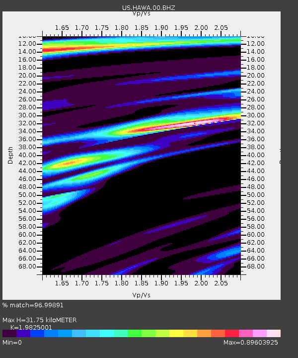
| Estimated Moho Depth: |
31.75 km |
| Estimated Crust Vp/Vs: |
1.98 |
| Assumed Crust Vp: |
6.419 km/s |
| Estimated Crust Vs: |
3.238 km/s |
| Estimated Crust Poisson's Ratio: |
0.33 |
|
| Radial Match: |
96.99891 % |
| Radial Bump: |
400 |
| Transverse Match: |
92.26219 % |
| Transverse Bump: |
400 |
| SOD ConfigId: |
29823551 |
| Insert Time: |
2022-12-18 20:57:09.928 +0000 |
| GWidth: |
2.5 |
| Max Bumps: |
400 |
| Tol: |
0.001 |
|

Signal To Noise
| Channel | StoN | STA | LTA |
| US:HAWA:00:BHZ:20221204T19:35:39.123995Z | 11.565712 | 4.583823E-6 | 3.9632863E-7 |
| US:HAWA:00:BH1:20221204T19:35:39.123995Z | 4.8152733 | 1.0292464E-6 | 2.137462E-7 |
| US:HAWA:00:BH2:20221204T19:35:39.123995Z | 6.5542245 | 1.240763E-6 | 1.8930739E-7 |
| Arrivals |
| Ps | 5.0 SECOND |
| PpPs | 14 SECOND |
| PsPs/PpSs | 19 SECOND |


