You are here: Home > Network List > US - United States National Seismic Network Stations List
> Station WRAK Wrangell Island, Southeastern Alaska, Alaska, USA > Earthquake Result Viewer
WRAK Wrangell Island, Southeastern Alaska, Alaska, USA - Earthquake Result Viewer
| Earthquake location: |
Samoa Islands Region |
| Earthquake latitude/longitude: |
-15.4/-173.0 |
| Earthquake time(UTC): |
2022/12/04 (338) 19:24:15 GMT |
| Earthquake Depth: |
36 km |
| Earthquake Magnitude: |
6.7 Mww |
| Earthquake Catalog/Contributor: |
NEIC PDE/us |
|
| Network: |
US United States National Seismic Network |
| Station: |
WRAK Wrangell Island, Southeastern Alaska, Alaska, USA |
| Lat/Lon: |
56.42 N/132.35 W |
| Elevation: |
81 m |
|
| Distance: |
79.2 deg |
| Az: |
21.612 deg |
| Baz: |
219.741 deg |
| Ray Param: |
0.049080588 |
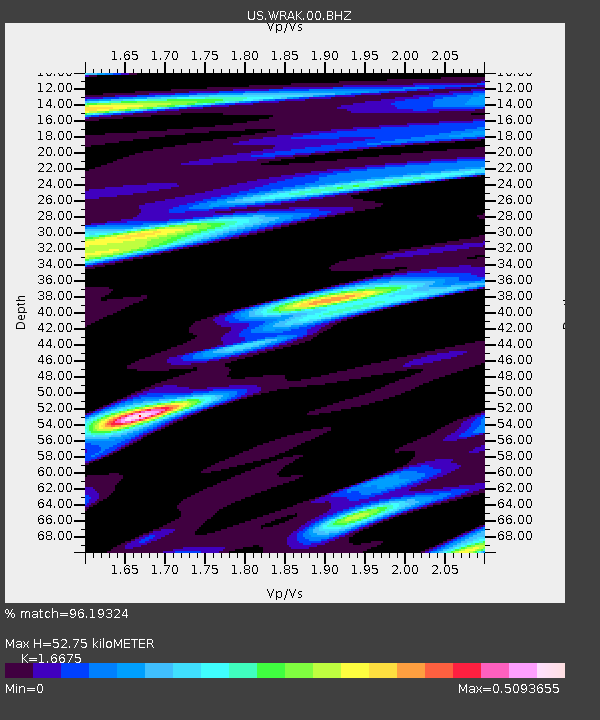
| Estimated Moho Depth: |
52.75 km |
| Estimated Crust Vp/Vs: |
1.67 |
| Assumed Crust Vp: |
6.597 km/s |
| Estimated Crust Vs: |
3.957 km/s |
| Estimated Crust Poisson's Ratio: |
0.22 |
|
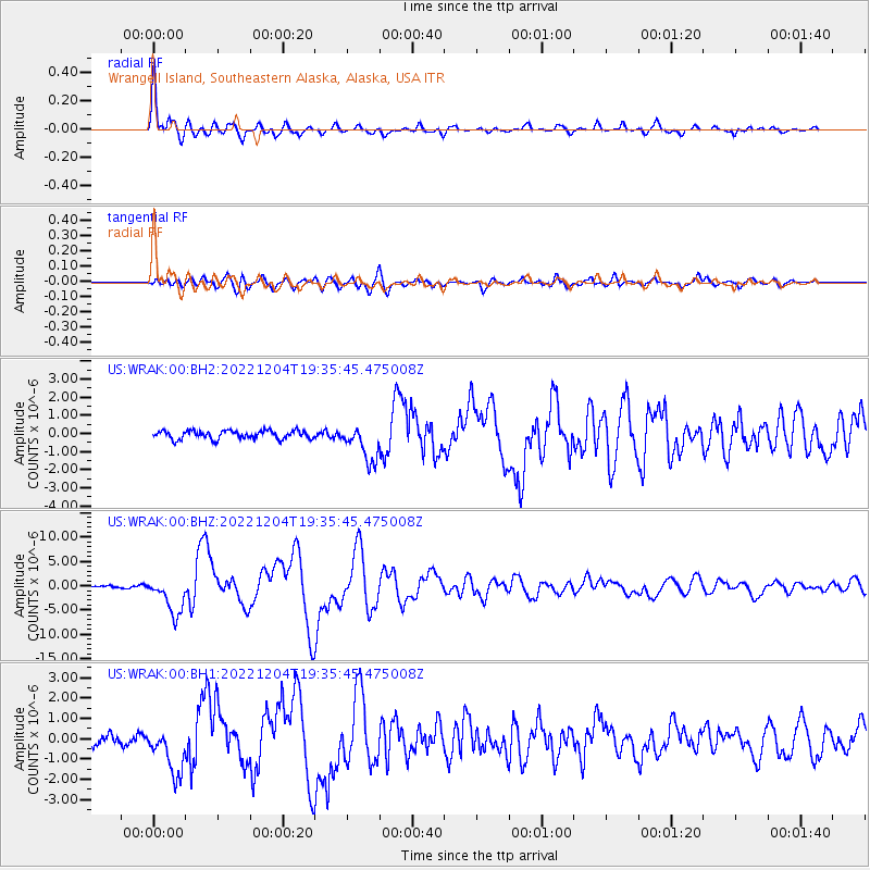
| Radial Match: |
96.19324 % |
| Radial Bump: |
400 |
| Transverse Match: |
89.73481 % |
| Transverse Bump: |
400 |
| SOD ConfigId: |
29823551 |
| Insert Time: |
2022-12-18 20:57:50.174 +0000 |
| GWidth: |
2.5 |
| Max Bumps: |
400 |
| Tol: |
0.001 |
|
Signal To Noise
| Channel | StoN | STA | LTA |
| US:WRAK:00:BHZ:20221204T19:35:45.475008Z | 18.864248 | 3.856457E-6 | 2.0443207E-7 |
| US:WRAK:00:BH1:20221204T19:35:45.475008Z | 7.1847634 | 1.1367403E-6 | 1.5821541E-7 |
| US:WRAK:00:BH2:20221204T19:35:45.475008Z | 4.350705 | 1.0098641E-6 | 2.3211504E-7 |
| Arrivals |
| Ps | 5.5 SECOND |
| PpPs | 21 SECOND |
| PsPs/PpSs | 26 SECOND |


