You are here: Home > Network List > UU - University of Utah Regional Network Stations List
> Station FOR6 FORGE > Earthquake Result Viewer
FOR6 FORGE - Earthquake Result Viewer
| Earthquake location: |
Samoa Islands Region |
| Earthquake latitude/longitude: |
-15.4/-173.0 |
| Earthquake time(UTC): |
2022/12/04 (338) 19:24:15 GMT |
| Earthquake Depth: |
36 km |
| Earthquake Magnitude: |
6.7 Mww |
| Earthquake Catalog/Contributor: |
NEIC PDE/us |
|
| Network: |
UU University of Utah Regional Network |
| Station: |
FOR6 FORGE |
| Lat/Lon: |
38.49 N/112.79 W |
| Elevation: |
2421 m |
|
| Distance: |
77.7 deg |
| Az: |
44.172 deg |
| Baz: |
238.923 deg |
| Ray Param: |
0.05009531 |
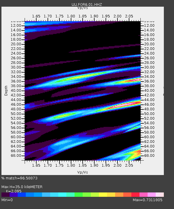
| Estimated Moho Depth: |
35.0 km |
| Estimated Crust Vp/Vs: |
2.10 |
| Assumed Crust Vp: |
6.276 km/s |
| Estimated Crust Vs: |
2.996 km/s |
| Estimated Crust Poisson's Ratio: |
0.35 |
|
| Radial Match: |
96.58873 % |
| Radial Bump: |
371 |
| Transverse Match: |
90.31937 % |
| Transverse Bump: |
400 |
| SOD ConfigId: |
29823551 |
| Insert Time: |
2022-12-18 20:58:06.464 +0000 |
| GWidth: |
2.5 |
| Max Bumps: |
400 |
| Tol: |
0.001 |
|

Signal To Noise
| Channel | StoN | STA | LTA |
| UU:FOR6:01:HHZ:20221204T19:35:37.31003Z | 28.381037 | 3.3880722E-6 | 1.1937803E-7 |
| UU:FOR6:01:HHN:20221204T19:35:37.31003Z | 2.27978 | 5.030513E-7 | 2.2065782E-7 |
| UU:FOR6:01:HHE:20221204T19:35:37.31003Z | 5.228107 | 9.912981E-7 | 1.8960937E-7 |
| Arrivals |
| Ps | 6.3 SECOND |
| PpPs | 17 SECOND |
| PsPs/PpSs | 23 SECOND |


