You are here: Home > Network List > UU - University of Utah Regional Network Stations List
> Station FOR7 FORGE > Earthquake Result Viewer
FOR7 FORGE - Earthquake Result Viewer
| Earthquake location: |
Samoa Islands Region |
| Earthquake latitude/longitude: |
-15.4/-173.0 |
| Earthquake time(UTC): |
2022/12/04 (338) 19:24:15 GMT |
| Earthquake Depth: |
36 km |
| Earthquake Magnitude: |
6.7 Mww |
| Earthquake Catalog/Contributor: |
NEIC PDE/us |
|
| Network: |
UU University of Utah Regional Network |
| Station: |
FOR7 FORGE |
| Lat/Lon: |
38.42 N/112.85 W |
| Elevation: |
1964 m |
|
| Distance: |
77.6 deg |
| Az: |
44.205 deg |
| Baz: |
238.89 deg |
| Ray Param: |
0.050148915 |
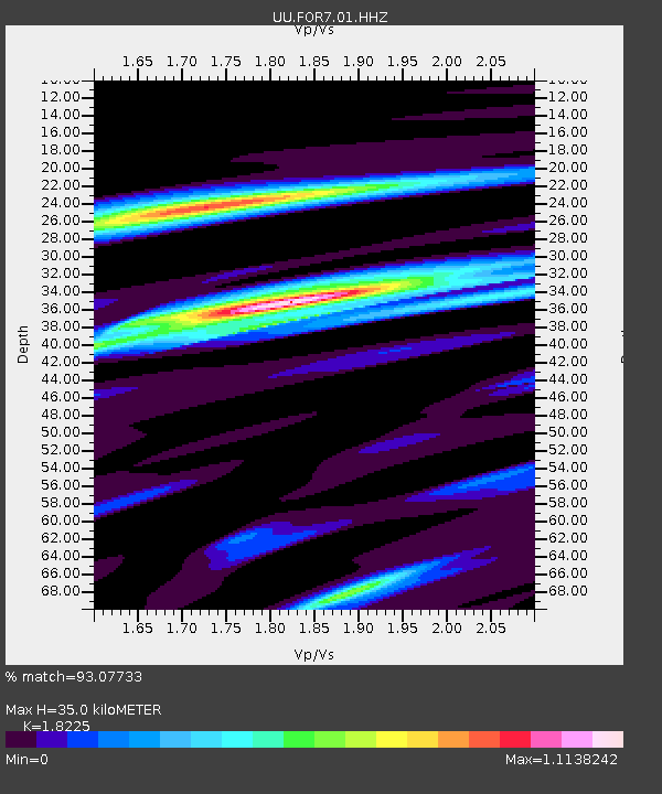
| Estimated Moho Depth: |
35.0 km |
| Estimated Crust Vp/Vs: |
1.82 |
| Assumed Crust Vp: |
6.276 km/s |
| Estimated Crust Vs: |
3.444 km/s |
| Estimated Crust Poisson's Ratio: |
0.28 |
|
| Radial Match: |
93.07733 % |
| Radial Bump: |
385 |
| Transverse Match: |
87.82279 % |
| Transverse Bump: |
400 |
| SOD ConfigId: |
29823551 |
| Insert Time: |
2022-12-18 20:58:08.458 +0000 |
| GWidth: |
2.5 |
| Max Bumps: |
400 |
| Tol: |
0.001 |
|

Signal To Noise
| Channel | StoN | STA | LTA |
| UU:FOR7:01:HHZ:20221204T19:35:36.865023Z | 28.10822 | 3.8004905E-6 | 1.3520922E-7 |
| UU:FOR7:01:HHN:20221204T19:35:36.865023Z | 3.945114 | 8.4565823E-7 | 2.1435584E-7 |
| UU:FOR7:01:HHE:20221204T19:35:36.865023Z | 8.700921 | 1.6156351E-6 | 1.8568552E-7 |
| Arrivals |
| Ps | 4.7 SECOND |
| PpPs | 15 SECOND |
| PsPs/PpSs | 20 SECOND |


