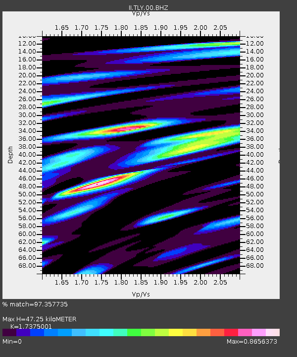
TLY Talaya, Russia - Earthquake Result Viewer

Earthquake location: Southern Sumatra, Indonesia
Earthquake latitude/longitude: -3.8/101.0
Earthquake time(UTC): 2010/03/05 (064) 16:07:03 GMT
Earthquake Depth: 35 km
Earthquake Magnitude: 6.0 MB, 6.6 MS, 6.8 MW, 6.7 MW
Earthquake Catalog/Contributor: WHDF/NEIC
Network: II Global Seismograph Network (GSN - IRIS/IDA)
Station: TLY Talaya, Russia
Lat/Lon: 51.68 N/103.64 E
Elevation: 579 m
Distance: 55.3 deg
Az: 2.012 deg
Baz: 183.226 deg
Ray Param: 0.06483567
Estimated Moho Depth: 47.25 km
Estimated Crust Vp/Vs: 1.74
Assumed Crust Vp: 6.419 km/s
Estimated Crust Vs: 3.695 km/s
Estimated Crust Poisson's Ratio: 0.25
Radial Match: 97.357735 %
Radial Bump: 400
Transverse Match: 91.54859 %
Transverse Bump: 400
SOD ConfigId: 299721
Insert Time: 2010-04-26 17:19:39.199 +0000
GWidth: 2.5
Max Bumps: 400
Tol: 0.001

Signal To Noise

ChannelStoNSTALTA
II:TLY:00:BHZ:20100305T16:16:02.239026Z47.771633.4193379E-67.157675E-8
II:TLY:00:BHN:20100305T16:16:02.239026Z51.257881.6815463E-63.2805616E-8
II:TLY:00:BHE:20100305T16:16:02.239026Z4.8953521.7650909E-73.6056466E-8
Arrivals
Ps5.7 SECOND
PpPs19 SECOND
PsPs/PpSs25 SECOND