You are here: Home > Network List > UW - Pacific Northwest Regional Seismic Network Stations List
> Station ASR2 Mt. Adams - Stagman Ridge, WA, USA > Earthquake Result Viewer
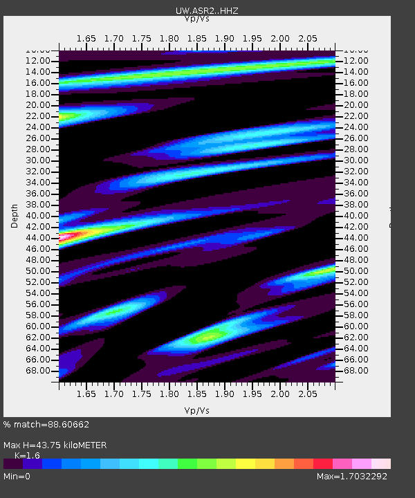
ASR2 Mt. Adams - Stagman Ridge, WA, USA - Earthquake Result Viewer
| Earthquake location: |
Samoa Islands Region |
| Earthquake latitude/longitude: |
-15.4/-173.0 |
| Earthquake time(UTC): |
2022/12/04 (338) 19:24:15 GMT |
| Earthquake Depth: |
36 km |
| Earthquake Magnitude: |
6.7 Mww |
| Earthquake Catalog/Contributor: |
NEIC PDE/us |
|
| Network: |
UW Pacific Northwest Regional Seismic Network |
| Station: |
ASR2 Mt. Adams - Stagman Ridge, WA, USA |
| Lat/Lon: |
46.14 N/121.60 W |
| Elevation: |
1274 m |
|
| Distance: |
76.8 deg |
| Az: |
33.919 deg |
| Baz: |
230.723 deg |
| Ray Param: |
0.050728463 |
| Estimated Moho Depth: |
43.75 km |
| Estimated Crust Vp/Vs: |
1.60 |
| Assumed Crust Vp: |
6.597 km/s |
| Estimated Crust Vs: |
4.123 km/s |
| Estimated Crust Poisson's Ratio: |
0.18 |
|
| Radial Match: |
88.60662 % |
| Radial Bump: |
400 |
| Transverse Match: |
77.39603 % |
| Transverse Bump: |
400 |
| SOD ConfigId: |
29823551 |
| Insert Time: |
2022-12-18 20:58:45.718 +0000 |
| GWidth: |
2.5 |
| Max Bumps: |
400 |
| Tol: |
0.001 |
|

Signal To Noise
| Channel | StoN | STA | LTA |
| UW:ASR2: :HHZ:20221204T19:35:31.990023Z | 11.666966 | 4.630632E-6 | 3.9690107E-7 |
| UW:ASR2: :HHN:20221204T19:35:31.990023Z | 2.9633665 | 1.1528633E-6 | 3.8903838E-7 |
| UW:ASR2: :HHE:20221204T19:35:31.990023Z | 3.7116036 | 1.4858103E-6 | 4.0031495E-7 |
| Arrivals |
| Ps | 4.1 SECOND |
| PpPs | 17 SECOND |
| PsPs/PpSs | 21 SECOND |


