You are here: Home > Network List > UW - Pacific Northwest Regional Seismic Network Stations List
> Station CROWN Crown Point, Clallam County, WA, USA > Earthquake Result Viewer
CROWN Crown Point, Clallam County, WA, USA - Earthquake Result Viewer
| Earthquake location: |
Samoa Islands Region |
| Earthquake latitude/longitude: |
-15.4/-173.0 |
| Earthquake time(UTC): |
2022/12/04 (338) 19:24:15 GMT |
| Earthquake Depth: |
36 km |
| Earthquake Magnitude: |
6.7 Mww |
| Earthquake Catalog/Contributor: |
NEIC PDE/us |
|
| Network: |
UW Pacific Northwest Regional Seismic Network |
| Station: |
CROWN Crown Point, Clallam County, WA, USA |
| Lat/Lon: |
48.30 N/124.48 W |
| Elevation: |
399 m |
|
| Distance: |
76.7 deg |
| Az: |
30.917 deg |
| Baz: |
227.924 deg |
| Ray Param: |
0.05078326 |
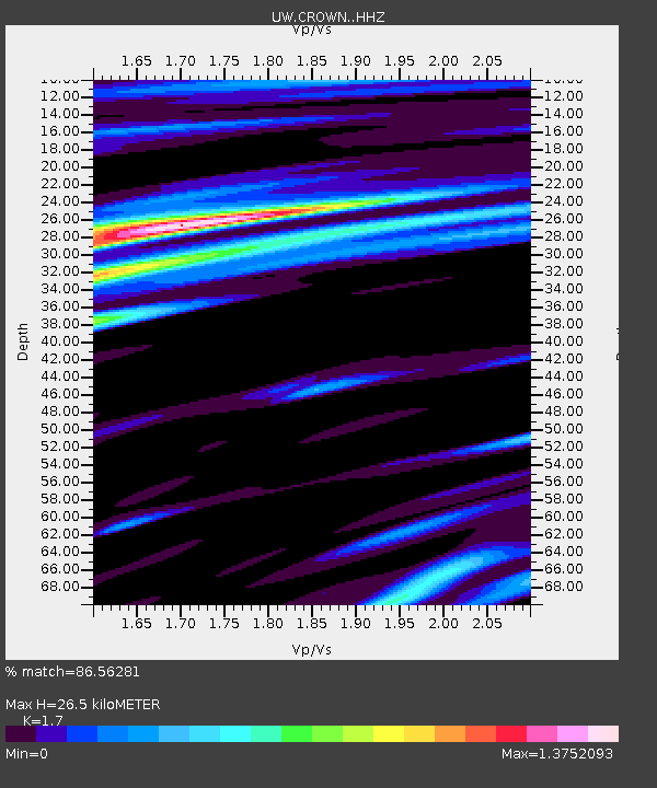
| Estimated Moho Depth: |
26.5 km |
| Estimated Crust Vp/Vs: |
1.70 |
| Assumed Crust Vp: |
6.391 km/s |
| Estimated Crust Vs: |
3.759 km/s |
| Estimated Crust Poisson's Ratio: |
0.24 |
|
| Radial Match: |
86.56281 % |
| Radial Bump: |
400 |
| Transverse Match: |
66.86864 % |
| Transverse Bump: |
387 |
| SOD ConfigId: |
29823551 |
| Insert Time: |
2022-12-18 20:59:23.158 +0000 |
| GWidth: |
2.5 |
| Max Bumps: |
400 |
| Tol: |
0.001 |
|

Signal To Noise
| Channel | StoN | STA | LTA |
| UW:CROWN: :HHZ:20221204T19:35:31.550021Z | 5.636318 | 5.254194E-6 | 9.322032E-7 |
| UW:CROWN: :HHN:20221204T19:35:31.550021Z | 1.2174082 | 1.4015661E-6 | 1.1512706E-6 |
| UW:CROWN: :HHE:20221204T19:35:31.550021Z | 1.499077 | 1.3652851E-6 | 9.1075054E-7 |
| Arrivals |
| Ps | 3.0 SECOND |
| PpPs | 11 SECOND |
| PsPs/PpSs | 14 SECOND |


