You are here: Home > Network List > UW - Pacific Northwest Regional Seismic Network Stations List
> Station FORK Forks, WA, USA > Earthquake Result Viewer
FORK Forks, WA, USA - Earthquake Result Viewer
| Earthquake location: |
Samoa Islands Region |
| Earthquake latitude/longitude: |
-15.4/-173.0 |
| Earthquake time(UTC): |
2022/12/04 (338) 19:24:15 GMT |
| Earthquake Depth: |
36 km |
| Earthquake Magnitude: |
6.7 Mww |
| Earthquake Catalog/Contributor: |
NEIC PDE/us |
|
| Network: |
UW Pacific Northwest Regional Seismic Network |
| Station: |
FORK Forks, WA, USA |
| Lat/Lon: |
47.95 N/124.57 W |
| Elevation: |
45 m |
|
| Distance: |
76.4 deg |
| Az: |
31.148 deg |
| Baz: |
227.913 deg |
| Ray Param: |
0.050975673 |
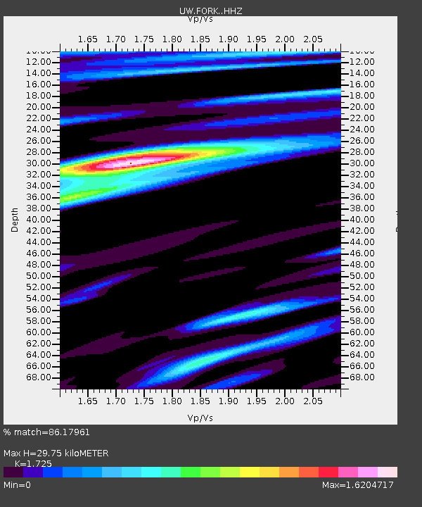
| Estimated Moho Depth: |
29.75 km |
| Estimated Crust Vp/Vs: |
1.73 |
| Assumed Crust Vp: |
6.134 km/s |
| Estimated Crust Vs: |
3.556 km/s |
| Estimated Crust Poisson's Ratio: |
0.25 |
|
| Radial Match: |
86.17961 % |
| Radial Bump: |
400 |
| Transverse Match: |
84.07962 % |
| Transverse Bump: |
400 |
| SOD ConfigId: |
29823551 |
| Insert Time: |
2022-12-18 20:59:56.511 +0000 |
| GWidth: |
2.5 |
| Max Bumps: |
400 |
| Tol: |
0.001 |
|

Signal To Noise
| Channel | StoN | STA | LTA |
| UW:FORK: :HHZ:20221204T19:35:29.959994Z | 4.54292 | 5.4955317E-6 | 1.2096915E-6 |
| UW:FORK: :HHN:20221204T19:35:29.959994Z | 1.4369701 | 2.6083221E-6 | 1.8151542E-6 |
| UW:FORK: :HHE:20221204T19:35:29.959994Z | 1.7980131 | 1.7849094E-6 | 9.927121E-7 |
| Arrivals |
| Ps | 3.6 SECOND |
| PpPs | 13 SECOND |
| PsPs/PpSs | 16 SECOND |


