You are here: Home > Network List > UW - Pacific Northwest Regional Seismic Network Stations List
> Station LEID Weyerhaeuser Tree Farm, Grays Harbor County, WA, USA > Earthquake Result Viewer
LEID Weyerhaeuser Tree Farm, Grays Harbor County, WA, USA - Earthquake Result Viewer
| Earthquake location: |
Samoa Islands Region |
| Earthquake latitude/longitude: |
-15.4/-173.0 |
| Earthquake time(UTC): |
2022/12/04 (338) 19:24:15 GMT |
| Earthquake Depth: |
36 km |
| Earthquake Magnitude: |
6.7 Mww |
| Earthquake Catalog/Contributor: |
NEIC PDE/us |
|
| Network: |
UW Pacific Northwest Regional Seismic Network |
| Station: |
LEID Weyerhaeuser Tree Farm, Grays Harbor County, WA, USA |
| Lat/Lon: |
46.83 N/123.47 W |
| Elevation: |
535 m |
|
| Distance: |
76.2 deg |
| Az: |
32.521 deg |
| Baz: |
229.046 deg |
| Ray Param: |
0.051096115 |
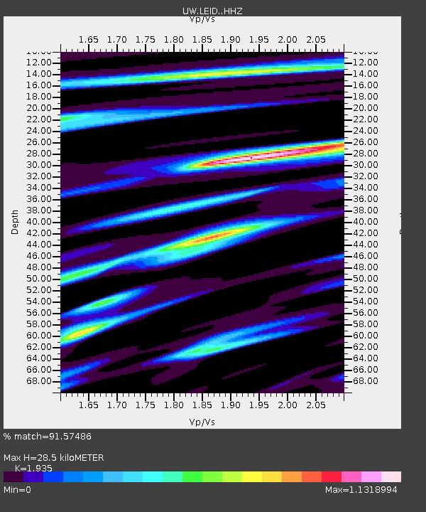
| Estimated Moho Depth: |
28.5 km |
| Estimated Crust Vp/Vs: |
1.93 |
| Assumed Crust Vp: |
6.566 km/s |
| Estimated Crust Vs: |
3.393 km/s |
| Estimated Crust Poisson's Ratio: |
0.32 |
|
| Radial Match: |
91.57486 % |
| Radial Bump: |
400 |
| Transverse Match: |
82.66987 % |
| Transverse Bump: |
373 |
| SOD ConfigId: |
29823551 |
| Insert Time: |
2022-12-18 21:00:47.803 +0000 |
| GWidth: |
2.5 |
| Max Bumps: |
400 |
| Tol: |
0.001 |
|

Signal To Noise
| Channel | StoN | STA | LTA |
| UW:LEID: :HHZ:20221204T19:35:28.930025Z | 13.421313 | 4.9941523E-6 | 3.721061E-7 |
| UW:LEID: :HHN:20221204T19:35:28.930025Z | 2.75791 | 1.409766E-6 | 5.1117183E-7 |
| UW:LEID: :HHE:20221204T19:35:28.930025Z | 3.5034761 | 1.6776225E-6 | 4.7884515E-7 |
| Arrivals |
| Ps | 4.2 SECOND |
| PpPs | 12 SECOND |
| PsPs/PpSs | 17 SECOND |


