You are here: Home > Network List > UW - Pacific Northwest Regional Seismic Network Stations List
> Station MANO Manastash Observatory, WA, USA > Earthquake Result Viewer
MANO Manastash Observatory, WA, USA - Earthquake Result Viewer
| Earthquake location: |
Samoa Islands Region |
| Earthquake latitude/longitude: |
-15.4/-173.0 |
| Earthquake time(UTC): |
2022/12/04 (338) 19:24:15 GMT |
| Earthquake Depth: |
36 km |
| Earthquake Magnitude: |
6.7 Mww |
| Earthquake Catalog/Contributor: |
NEIC PDE/us |
|
| Network: |
UW Pacific Northwest Regional Seismic Network |
| Station: |
MANO Manastash Observatory, WA, USA |
| Lat/Lon: |
46.95 N/120.72 W |
| Elevation: |
1200 m |
|
| Distance: |
77.7 deg |
| Az: |
33.661 deg |
| Baz: |
231.297 deg |
| Ray Param: |
0.050076652 |
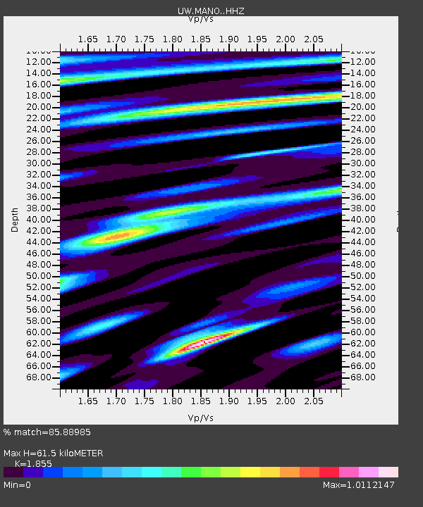
| Estimated Moho Depth: |
61.5 km |
| Estimated Crust Vp/Vs: |
1.86 |
| Assumed Crust Vp: |
6.597 km/s |
| Estimated Crust Vs: |
3.557 km/s |
| Estimated Crust Poisson's Ratio: |
0.30 |
|
| Radial Match: |
85.88985 % |
| Radial Bump: |
400 |
| Transverse Match: |
83.80759 % |
| Transverse Bump: |
400 |
| SOD ConfigId: |
29823551 |
| Insert Time: |
2022-12-18 21:01:07.294 +0000 |
| GWidth: |
2.5 |
| Max Bumps: |
400 |
| Tol: |
0.001 |
|

Signal To Noise
| Channel | StoN | STA | LTA |
| UW:MANO: :HHZ:20221204T19:35:37.459994Z | 9.235058 | 5.0748336E-6 | 5.4951835E-7 |
| UW:MANO: :HHN:20221204T19:35:37.459994Z | 3.3591034 | 1.3230417E-6 | 3.938675E-7 |
| UW:MANO: :HHE:20221204T19:35:37.459994Z | 3.729745 | 1.5569009E-6 | 4.1742823E-7 |
| Arrivals |
| Ps | 8.2 SECOND |
| PpPs | 26 SECOND |
| PsPs/PpSs | 34 SECOND |


