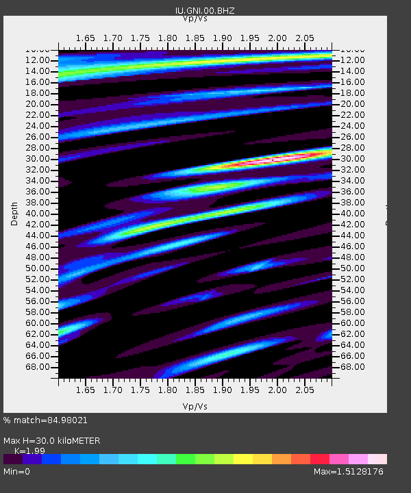
GNI Garni, Armenia - Earthquake Result Viewer
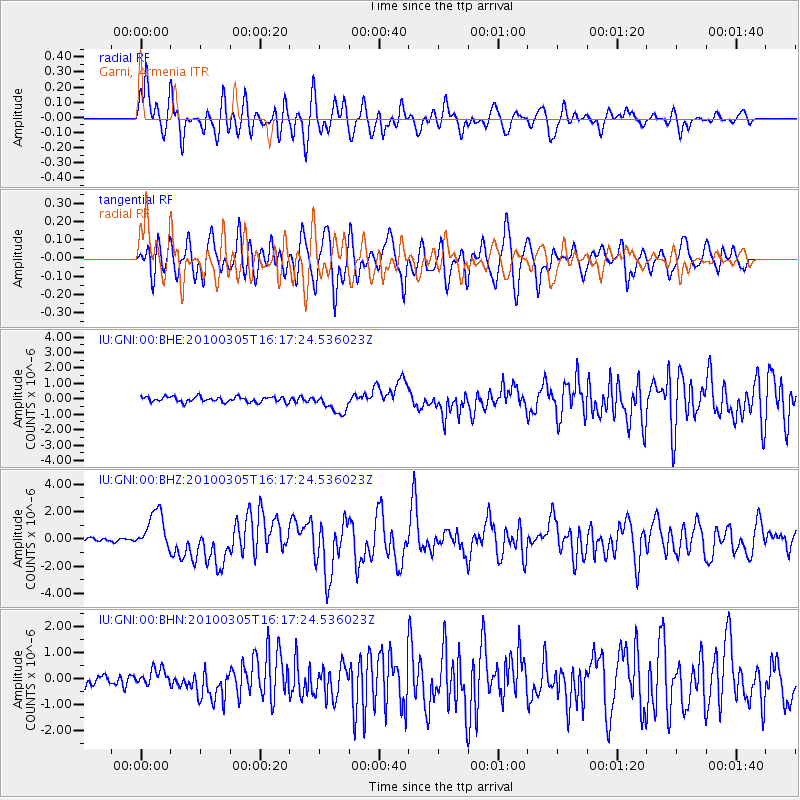
Earthquake location: Southern Sumatra, Indonesia
Earthquake latitude/longitude: -3.8/101.0
Earthquake time(UTC): 2010/03/05 (064) 16:07:03 GMT
Earthquake Depth: 35 km
Earthquake Magnitude: 6.0 MB, 6.6 MS, 6.8 MW, 6.7 MW
Earthquake Catalog/Contributor: WHDF/NEIC
Network: IU Global Seismograph Network (GSN - IRIS/USGS)
Station: GNI Garni, Armenia
Lat/Lon: 40.15 N/44.74 E
Elevation: 1609 m
Distance: 67.5 deg
Az: 316.373 deg
Baz: 116.074 deg
Ray Param: 0.056880124
Estimated Moho Depth: 30.0 km
Estimated Crust Vp/Vs: 1.99
Assumed Crust Vp: 6.291 km/s
Estimated Crust Vs: 3.161 km/s
Estimated Crust Poisson's Ratio: 0.33
Radial Match: 84.98021 %
Radial Bump: 400
Transverse Match: 77.005486 %
Transverse Bump: 400
SOD ConfigId: 299721
Insert Time: 2010-04-26 17:20:12.525 +0000
GWidth: 2.5
Max Bumps: 400
Tol: 0.001

Signal To Noise

ChannelStoNSTALTA
IU:GNI:00:BHZ:20100305T16:17:24.536023Z10.3272281.4234112E-61.3783091E-7
IU:GNI:00:BHN:20100305T16:17:24.536023Z1.83168483.287244E-71.7946559E-7
IU:GNI:00:BHE:20100305T16:17:24.536023Z3.62704426.2532536E-71.7240632E-7
Arrivals
Ps4.9 SECOND
PpPs14 SECOND
PsPs/PpSs19 SECOND