You are here: Home > Network List > UW - Pacific Northwest Regional Seismic Network Stations List
> Station SAXON Nesset Farm, Saxon, WA, USA > Earthquake Result Viewer
SAXON Nesset Farm, Saxon, WA, USA - Earthquake Result Viewer
| Earthquake location: |
Samoa Islands Region |
| Earthquake latitude/longitude: |
-15.4/-173.0 |
| Earthquake time(UTC): |
2022/12/04 (338) 19:24:15 GMT |
| Earthquake Depth: |
36 km |
| Earthquake Magnitude: |
6.7 Mww |
| Earthquake Catalog/Contributor: |
NEIC PDE/us |
|
| Network: |
UW Pacific Northwest Regional Seismic Network |
| Station: |
SAXON Nesset Farm, Saxon, WA, USA |
| Lat/Lon: |
48.68 N/122.16 W |
| Elevation: |
111 m |
|
| Distance: |
78.1 deg |
| Az: |
31.663 deg |
| Baz: |
229.818 deg |
| Ray Param: |
0.04983348 |
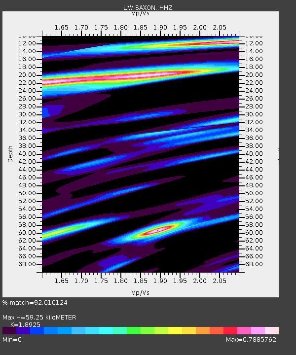
| Estimated Moho Depth: |
59.25 km |
| Estimated Crust Vp/Vs: |
1.89 |
| Assumed Crust Vp: |
6.566 km/s |
| Estimated Crust Vs: |
3.47 km/s |
| Estimated Crust Poisson's Ratio: |
0.31 |
|
| Radial Match: |
92.010124 % |
| Radial Bump: |
329 |
| Transverse Match: |
92.62555 % |
| Transverse Bump: |
400 |
| SOD ConfigId: |
29823551 |
| Insert Time: |
2022-12-18 21:02:07.967 +0000 |
| GWidth: |
2.5 |
| Max Bumps: |
400 |
| Tol: |
0.001 |
|

Signal To Noise
| Channel | StoN | STA | LTA |
| UW:SAXON: :HHZ:20221204T19:35:39.420016Z | 11.677088 | 4.4728085E-6 | 3.8304145E-7 |
| UW:SAXON: :HHN:20221204T19:35:39.420016Z | 4.3208747 | 8.6270927E-7 | 1.9966079E-7 |
| UW:SAXON: :HHE:20221204T19:35:39.420016Z | 3.768394 | 1.0781325E-6 | 2.8609867E-7 |
| Arrivals |
| Ps | 8.3 SECOND |
| PpPs | 25 SECOND |
| PsPs/PpSs | 34 SECOND |


