You are here: Home > Network List > UW - Pacific Northwest Regional Seismic Network Stations List
> Station TREE Summer Lake, OR, USA > Earthquake Result Viewer
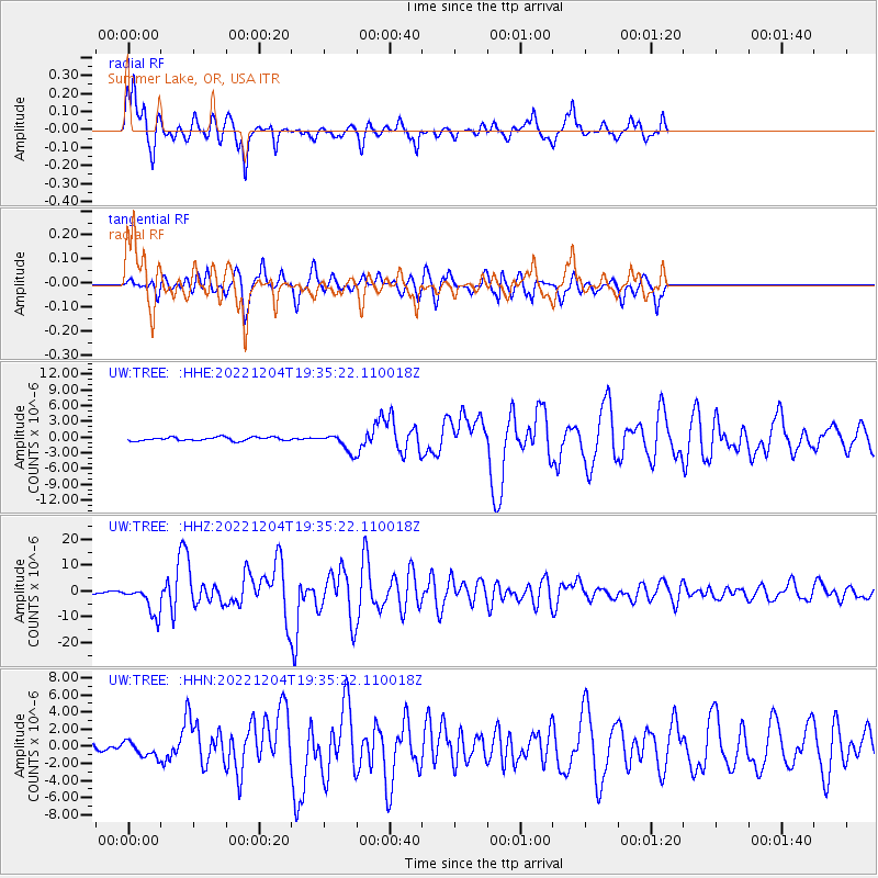
TREE Summer Lake, OR, USA - Earthquake Result Viewer
| Earthquake location: |
Samoa Islands Region |
| Earthquake latitude/longitude: |
-15.4/-173.0 |
| Earthquake time(UTC): |
2022/12/04 (338) 19:24:15 GMT |
| Earthquake Depth: |
36 km |
| Earthquake Magnitude: |
6.7 Mww |
| Earthquake Catalog/Contributor: |
NEIC PDE/us |
|
| Network: |
UW Pacific Northwest Regional Seismic Network |
| Station: |
TREE Summer Lake, OR, USA |
| Lat/Lon: |
42.73 N/120.89 W |
| Elevation: |
1881 m |
|
| Distance: |
75.0 deg |
| Az: |
36.992 deg |
| Baz: |
231.963 deg |
| Ray Param: |
0.05189519 |
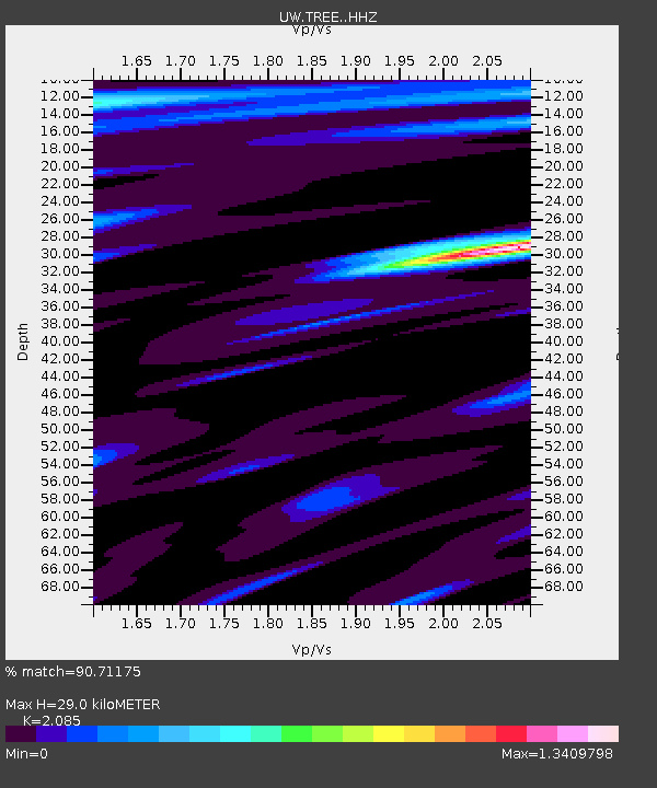
| Estimated Moho Depth: |
29.0 km |
| Estimated Crust Vp/Vs: |
2.09 |
| Assumed Crust Vp: |
6.597 km/s |
| Estimated Crust Vs: |
3.164 km/s |
| Estimated Crust Poisson's Ratio: |
0.35 |
|
| Radial Match: |
90.71175 % |
| Radial Bump: |
316 |
| Transverse Match: |
81.91276 % |
| Transverse Bump: |
400 |
| SOD ConfigId: |
29823551 |
| Insert Time: |
2022-12-18 21:02:43.749 +0000 |
| GWidth: |
2.5 |
| Max Bumps: |
400 |
| Tol: |
0.001 |
|
Signal To Noise
| Channel | StoN | STA | LTA |
| UW:TREE: :HHZ:20221204T19:35:22.110018Z | 11.196612 | 5.7803495E-6 | 5.162588E-7 |
| UW:TREE: :HHN:20221204T19:35:22.110018Z | 3.2589853 | 8.957853E-7 | 2.7486632E-7 |
| UW:TREE: :HHE:20221204T19:35:22.110018Z | 4.9083695 | 1.6504536E-6 | 3.362529E-7 |
| Arrivals |
| Ps | 4.9 SECOND |
| PpPs | 13 SECOND |
| PsPs/PpSs | 18 SECOND |


