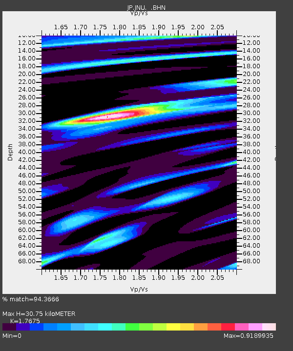
JNU Oita Nakatsue - Earthquake Result Viewer

Earthquake location: Southern Sumatra, Indonesia
Earthquake latitude/longitude: -3.8/101.0
Earthquake time(UTC): 2010/03/05 (064) 16:07:03 GMT
Earthquake Depth: 35 km
Earthquake Magnitude: 6.0 MB, 6.6 MS, 6.8 MW, 6.7 MW
Earthquake Catalog/Contributor: WHDF/NEIC
Network: JP Japan Meteorological Agency Seismic Network
Station: JNU Oita Nakatsue
Lat/Lon: 33.12 N/130.88 E
Elevation: 540 m
Distance: 46.3 deg
Az: 35.323 deg
Baz: 223.437 deg
Ray Param: 0.070646144
Estimated Moho Depth: 30.75 km
Estimated Crust Vp/Vs: 1.77
Assumed Crust Vp: 6.468 km/s
Estimated Crust Vs: 3.659 km/s
Estimated Crust Poisson's Ratio: 0.26
Radial Match: 94.3666 %
Radial Bump: 400
Transverse Match: 79.25806 %
Transverse Bump: 400
SOD ConfigId: 299721
Insert Time: 2010-04-26 17:20:39.883 +0000
GWidth: 2.5
Max Bumps: 400
Tol: 0.001

Signal To Noise

ChannelStoNSTALTA
JP:JNU: :BHZ:20100305T16:14:55.000012Z16.8064633.896976E-62.3187366E-7
JP:JNU: :BHN:20100305T16:14:55.000012Z6.81819871.5628497E-62.2921739E-7
JP:JNU: :BHE:20100305T16:14:55.000012Z7.897871.3512138E-61.7108584E-7
Arrivals
Ps3.9 SECOND
PpPs12 SECOND
PsPs/PpSs16 SECOND