You are here: Home > Network List > CB - China National Seismic Network Stations List
> Station HEH Heihe,Heilongjiang Province > Earthquake Result Viewer
HEH Heihe,Heilongjiang Province - Earthquake Result Viewer

| Earthquake location: |
Java, Indonesia |
| Earthquake latitude/longitude: |
-7.7/108.0 |
| Earthquake time(UTC): |
2017/12/15 (349) 16:47:56 GMT |
| Earthquake Depth: |
92 km |
| Earthquake Magnitude: |
6.5 Mww |
| Earthquake Catalog/Contributor: |
NEIC PDE/us |
|
| Network: |
CB China National Seismic Network |
| Station: |
HEH Heihe,Heilongjiang Province |
| Lat/Lon: |
50.25 N/127.41 E |
| Elevation: |
165 m |
|
| Distance: |
60.2 deg |
| Az: |
14.221 deg |
| Baz: |
202.287 deg |
| Ray Param: |
0.061457835 |
| Estimated Moho Depth: |
33.0 km |
| Estimated Crust Vp/Vs: |
1.76 |
| Assumed Crust Vp: |
6.419 km/s |
| Estimated Crust Vs: |
3.637 km/s |
| Estimated Crust Poisson's Ratio: |
0.26 |
|
| Radial Match: |
95.7639 % |
| Radial Bump: |
292 |
| Transverse Match: |
83.07716 % |
| Transverse Bump: |
400 |
| SOD ConfigId: |
2973751 |
| Insert Time: |
2018-10-09 04:20:08.560 +0000 |
| GWidth: |
2.5 |
| Max Bumps: |
400 |
| Tol: |
0.001 |
|
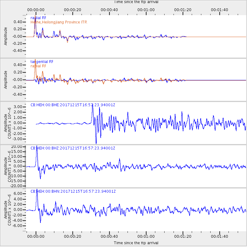
Signal To Noise
| Channel | StoN | STA | LTA |
| CB:HEH:00:BHZ:20171215T16:57:23.94001Z | 74.898445 | 7.8267E-6 | 1.04497495E-7 |
| CB:HEH:00:BHN:20171215T16:57:23.94001Z | 38.427044 | 2.8641355E-6 | 7.453436E-8 |
| CB:HEH:00:BHE:20171215T16:57:23.94001Z | 26.30125 | 1.7774461E-6 | 6.758028E-8 |
| Arrivals |
| Ps | 4.1 SECOND |
| PpPs | 14 SECOND |
| PsPs/PpSs | 18 SECOND |


