You are here: Home > Network List > CI - Caltech Regional Seismic Network Stations List
> Station SWS Sam W. Stewart, Westmorland, CA, USA > Earthquake Result Viewer
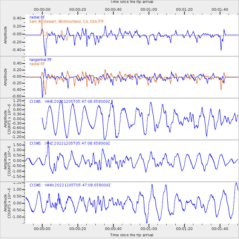
SWS Sam W. Stewart, Westmorland, CA, USA - Earthquake Result Viewer
*The percent match for this event was below the threshold and hence no stack was calculated.
| Earthquake location: |
Santa Cruz Islands |
| Earthquake latitude/longitude: |
-11.3/166.2 |
| Earthquake time(UTC): |
2022/12/05 (339) 05:35:08 GMT |
| Earthquake Depth: |
93 km |
| Earthquake Magnitude: |
5.7 mww |
| Earthquake Catalog/Contributor: |
NEIC PDE/us |
|
| Network: |
CI Caltech Regional Seismic Network |
| Station: |
SWS Sam W. Stewart, Westmorland, CA, USA |
| Lat/Lon: |
32.94 N/115.80 W |
| Elevation: |
140 m |
|
| Distance: |
86.2 deg |
| Az: |
55.518 deg |
| Baz: |
254.035 deg |
| Ray Param: |
$rayparam |
*The percent match for this event was below the threshold and hence was not used in the summary stack. |
|
| Radial Match: |
51.745815 % |
| Radial Bump: |
400 |
| Transverse Match: |
61.696598 % |
| Transverse Bump: |
395 |
| SOD ConfigId: |
29823551 |
| Insert Time: |
2022-12-19 05:47:06.039 +0000 |
| GWidth: |
2.5 |
| Max Bumps: |
400 |
| Tol: |
0.001 |
|
Signal To Noise
| Channel | StoN | STA | LTA |
| CI:SWS: :HHZ:20221205T05:47:08.658009Z | 2.9168043 | 7.25113E-7 | 2.4859844E-7 |
| CI:SWS: :HHN:20221205T05:47:08.658009Z | 1.2959969 | 4.4030241E-7 | 3.3974032E-7 |
| CI:SWS: :HHE:20221205T05:47:08.658009Z | 0.86308503 | 6.181198E-7 | 7.161749E-7 |
| Arrivals |
| Ps | |
| PpPs | |
| PsPs/PpSs | |


