You are here: Home > Network List > TA - USArray Transportable Network (new EarthScope stations) Stations List
> Station M23A Laramie, WY, USA > Earthquake Result Viewer
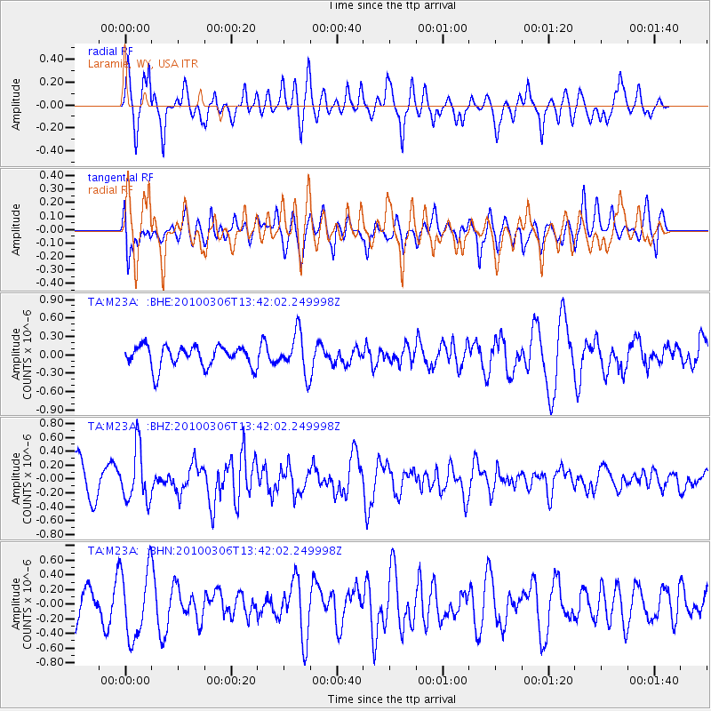
M23A Laramie, WY, USA - Earthquake Result Viewer
*The percent match for this event was below the threshold and hence no stack was calculated.
| Earthquake location: |
Kuril Islands |
| Earthquake latitude/longitude: |
44.2/147.6 |
| Earthquake time(UTC): |
2010/03/06 (065) 13:31:12 GMT |
| Earthquake Depth: |
53 km |
| Earthquake Magnitude: |
5.7 MW, 5.1 MS, 5.4 MB, 5.6 MW |
| Earthquake Catalog/Contributor: |
WHDF/NEIC |
|
| Network: |
TA USArray Transportable Network (new EarthScope stations) |
| Station: |
M23A Laramie, WY, USA |
| Lat/Lon: |
41.47 N/105.72 W |
| Elevation: |
2166 m |
|
| Distance: |
72.3 deg |
| Az: |
49.086 deg |
| Baz: |
313.651 deg |
| Ray Param: |
$rayparam |
*The percent match for this event was below the threshold and hence was not used in the summary stack. |
|
| Radial Match: |
79.61271 % |
| Radial Bump: |
387 |
| Transverse Match: |
65.073616 % |
| Transverse Bump: |
400 |
| SOD ConfigId: |
299721 |
| Insert Time: |
2010-04-26 17:31:20.546 +0000 |
| GWidth: |
2.5 |
| Max Bumps: |
400 |
| Tol: |
0.001 |
|
Signal To Noise
| Channel | StoN | STA | LTA |
| TA:M23A: :BHZ:20100306T13:42:02.249998Z | 1.7312691 | 3.8450182E-7 | 2.2209245E-7 |
| TA:M23A: :BHN:20100306T13:42:02.249998Z | 2.0543153 | 4.673366E-7 | 2.274902E-7 |
| TA:M23A: :BHE:20100306T13:42:02.249998Z | 1.8984516 | 3.2983243E-7 | 1.737376E-7 |
| Arrivals |
| Ps | |
| PpPs | |
| PsPs/PpSs | |


