You are here: Home > Network List > TA - USArray Transportable Network (new EarthScope stations) Stations List
> Station J22A Midwest, WY, USA > Earthquake Result Viewer
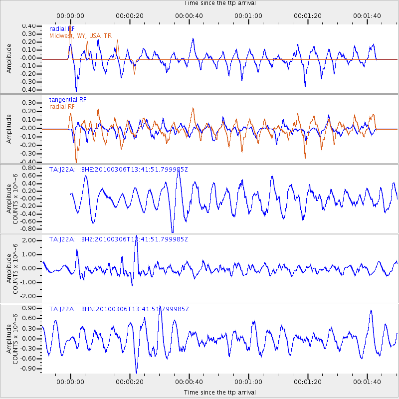
J22A Midwest, WY, USA - Earthquake Result Viewer
*The percent match for this event was below the threshold and hence no stack was calculated.
| Earthquake location: |
Kuril Islands |
| Earthquake latitude/longitude: |
44.2/147.6 |
| Earthquake time(UTC): |
2010/03/06 (065) 13:31:12 GMT |
| Earthquake Depth: |
53 km |
| Earthquake Magnitude: |
5.7 MW, 5.1 MS, 5.4 MB, 5.6 MW |
| Earthquake Catalog/Contributor: |
WHDF/NEIC |
|
| Network: |
TA USArray Transportable Network (new EarthScope stations) |
| Station: |
J22A Midwest, WY, USA |
| Lat/Lon: |
43.41 N/106.48 W |
| Elevation: |
1587 m |
|
| Distance: |
70.6 deg |
| Az: |
47.997 deg |
| Baz: |
312.797 deg |
| Ray Param: |
$rayparam |
*The percent match for this event was below the threshold and hence was not used in the summary stack. |
|
| Radial Match: |
57.14174 % |
| Radial Bump: |
400 |
| Transverse Match: |
69.64201 % |
| Transverse Bump: |
336 |
| SOD ConfigId: |
299721 |
| Insert Time: |
2010-04-26 17:31:38.163 +0000 |
| GWidth: |
2.5 |
| Max Bumps: |
400 |
| Tol: |
0.001 |
|
Signal To Noise
| Channel | StoN | STA | LTA |
| TA:J22A: :BHZ:20100306T13:41:51.799985Z | 2.1547577 | 5.307401E-7 | 2.4631078E-7 |
| TA:J22A: :BHN:20100306T13:41:51.799985Z | 0.4541274 | 2.0681824E-7 | 4.55419E-7 |
| TA:J22A: :BHE:20100306T13:41:51.799985Z | 1.6017761 | 4.0708437E-7 | 2.5414562E-7 |
| Arrivals |
| Ps | |
| PpPs | |
| PsPs/PpSs | |


