You are here: Home > Network List > IU - Global Seismograph Network (GSN - IRIS/USGS) Stations List
> Station CTAO Charters Towers, Australia > Earthquake Result Viewer
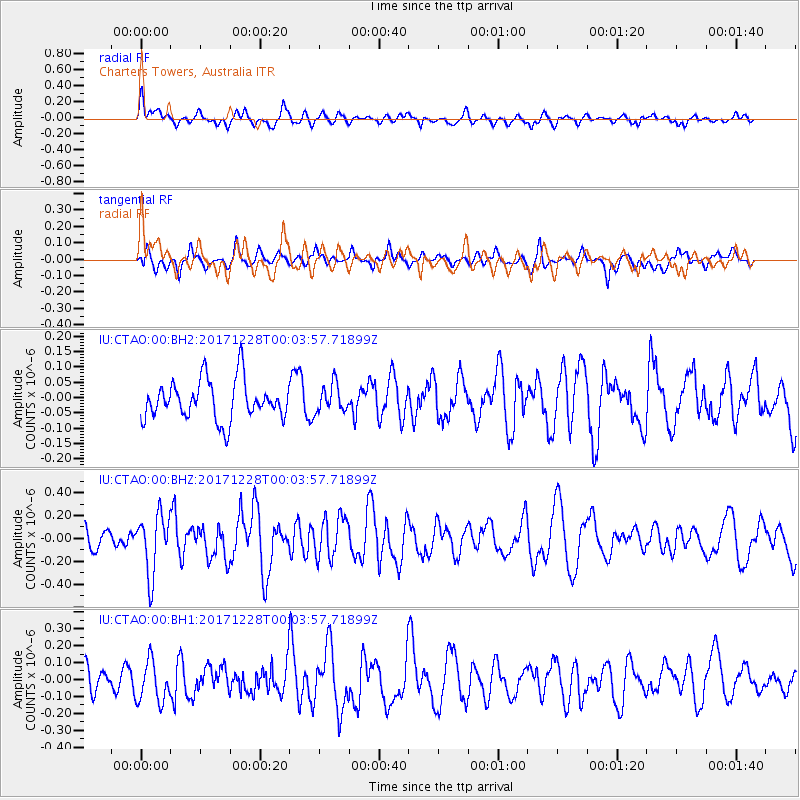
CTAO Charters Towers, Australia - Earthquake Result Viewer
*The percent match for this event was below the threshold and hence no stack was calculated.
| Earthquake location: |
South Of Mariana Islands |
| Earthquake latitude/longitude: |
12.0/144.4 |
| Earthquake time(UTC): |
2017/12/27 (361) 23:58:02 GMT |
| Earthquake Depth: |
15 km |
| Earthquake Magnitude: |
5.5 mb |
| Earthquake Catalog/Contributor: |
NEIC PDE/us |
|
| Network: |
IU Global Seismograph Network (GSN - IRIS/USGS) |
| Station: |
CTAO Charters Towers, Australia |
| Lat/Lon: |
20.09 S/146.25 E |
| Elevation: |
357 m |
|
| Distance: |
32.0 deg |
| Az: |
176.672 deg |
| Baz: |
356.536 deg |
| Ray Param: |
$rayparam |
*The percent match for this event was below the threshold and hence was not used in the summary stack. |
|
| Radial Match: |
58.470634 % |
| Radial Bump: |
400 |
| Transverse Match: |
60.364258 % |
| Transverse Bump: |
400 |
| SOD ConfigId: |
2973751 |
| Insert Time: |
2018-10-09 04:58:27.081 +0000 |
| GWidth: |
2.5 |
| Max Bumps: |
400 |
| Tol: |
0.001 |
|
Signal To Noise
| Channel | StoN | STA | LTA |
| IU:CTAO:00:BHZ:20171228T00:03:57.71899Z | 2.4497993 | 2.585169E-7 | 1.0552576E-7 |
| IU:CTAO:00:BH1:20171228T00:03:57.71899Z | 0.96718925 | 1.2129355E-7 | 1.254083E-7 |
| IU:CTAO:00:BH2:20171228T00:03:57.71899Z | 0.7236325 | 4.6575238E-8 | 6.436311E-8 |
| Arrivals |
| Ps | |
| PpPs | |
| PsPs/PpSs | |


