You are here: Home > Network List > US - United States National Seismic Network Stations List
> Station MNTX Cornudas Mountains, Texas, USA > Earthquake Result Viewer
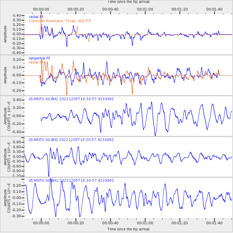
MNTX Cornudas Mountains, Texas, USA - Earthquake Result Viewer
*The percent match for this event was below the threshold and hence no stack was calculated.
| Earthquake location: |
Tonga Islands |
| Earthquake latitude/longitude: |
-15.2/-173.1 |
| Earthquake time(UTC): |
2022/12/05 (339) 16:19:19 GMT |
| Earthquake Depth: |
10 km |
| Earthquake Magnitude: |
5.6 Mww |
| Earthquake Catalog/Contributor: |
NEIC PDE/us |
|
| Network: |
US United States National Seismic Network |
| Station: |
MNTX Cornudas Mountains, Texas, USA |
| Lat/Lon: |
31.70 N/105.38 W |
| Elevation: |
405 m |
|
| Distance: |
79.9 deg |
| Az: |
53.251 deg |
| Baz: |
245.156 deg |
| Ray Param: |
$rayparam |
*The percent match for this event was below the threshold and hence was not used in the summary stack. |
|
| Radial Match: |
59.05793 % |
| Radial Bump: |
400 |
| Transverse Match: |
44.143124 % |
| Transverse Bump: |
400 |
| SOD ConfigId: |
29823551 |
| Insert Time: |
2022-12-19 16:47:51.964 +0000 |
| GWidth: |
2.5 |
| Max Bumps: |
400 |
| Tol: |
0.001 |
|
Signal To Noise
| Channel | StoN | STA | LTA |
| US:MNTX:00:BHZ:20221205T16:30:57.423996Z | 2.0272787 | 3.861306E-7 | 1.9046746E-7 |
| US:MNTX:00:BH1:20221205T16:30:57.423996Z | 0.38665932 | 7.4912364E-8 | 1.9374255E-7 |
| US:MNTX:00:BH2:20221205T16:30:57.423996Z | 2.1075656 | 1.4210515E-7 | 6.742621E-8 |
| Arrivals |
| Ps | |
| PpPs | |
| PsPs/PpSs | |


