You are here: Home > Network List > UW - Pacific Northwest Regional Seismic Network Stations List
> Station UMAT Pilot Rock, OR, USA > Earthquake Result Viewer
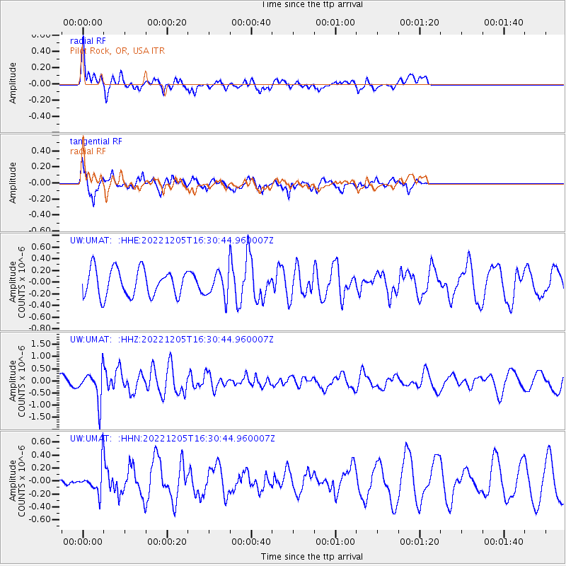
UMAT Pilot Rock, OR, USA - Earthquake Result Viewer
*The percent match for this event was below the threshold and hence no stack was calculated.
| Earthquake location: |
Tonga Islands |
| Earthquake latitude/longitude: |
-15.2/-173.1 |
| Earthquake time(UTC): |
2022/12/05 (339) 16:19:19 GMT |
| Earthquake Depth: |
10 km |
| Earthquake Magnitude: |
5.6 Mww |
| Earthquake Catalog/Contributor: |
NEIC PDE/us |
|
| Network: |
UW Pacific Northwest Regional Seismic Network |
| Station: |
UMAT Pilot Rock, OR, USA |
| Lat/Lon: |
45.29 N/118.96 W |
| Elevation: |
1318 m |
|
| Distance: |
77.6 deg |
| Az: |
35.862 deg |
| Baz: |
233.242 deg |
| Ray Param: |
$rayparam |
*The percent match for this event was below the threshold and hence was not used in the summary stack. |
|
| Radial Match: |
73.044815 % |
| Radial Bump: |
400 |
| Transverse Match: |
78.04472 % |
| Transverse Bump: |
390 |
| SOD ConfigId: |
29823551 |
| Insert Time: |
2022-12-19 16:51:15.793 +0000 |
| GWidth: |
2.5 |
| Max Bumps: |
400 |
| Tol: |
0.001 |
|
Signal To Noise
| Channel | StoN | STA | LTA |
| UW:UMAT: :HHZ:20221205T16:30:44.960007Z | 3.0723174 | 6.298085E-7 | 2.049946E-7 |
| UW:UMAT: :HHN:20221205T16:30:44.960007Z | 0.6670939 | 2.009917E-7 | 3.012945E-7 |
| UW:UMAT: :HHE:20221205T16:30:44.960007Z | 0.9534923 | 2.197113E-7 | 2.3042799E-7 |
| Arrivals |
| Ps | |
| PpPs | |
| PsPs/PpSs | |


