You are here: Home > Network List > TA - USArray Transportable Network (new EarthScope stations) Stations List
> Station 332A Millersview, TX, USA > Earthquake Result Viewer
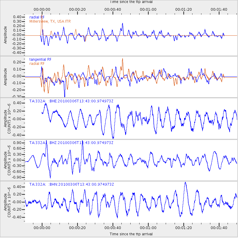
332A Millersview, TX, USA - Earthquake Result Viewer
*The percent match for this event was below the threshold and hence no stack was calculated.
| Earthquake location: |
Kuril Islands |
| Earthquake latitude/longitude: |
44.2/147.6 |
| Earthquake time(UTC): |
2010/03/06 (065) 13:31:12 GMT |
| Earthquake Depth: |
53 km |
| Earthquake Magnitude: |
5.7 MW, 5.1 MS, 5.4 MB, 5.6 MW |
| Earthquake Catalog/Contributor: |
WHDF/NEIC |
|
| Network: |
TA USArray Transportable Network (new EarthScope stations) |
| Station: |
332A Millersview, TX, USA |
| Lat/Lon: |
31.38 N/99.74 W |
| Elevation: |
513 m |
|
| Distance: |
82.9 deg |
| Az: |
52.711 deg |
| Baz: |
317.982 deg |
| Ray Param: |
$rayparam |
*The percent match for this event was below the threshold and hence was not used in the summary stack. |
|
| Radial Match: |
43.150146 % |
| Radial Bump: |
400 |
| Transverse Match: |
47.6791 % |
| Transverse Bump: |
378 |
| SOD ConfigId: |
299721 |
| Insert Time: |
2010-04-26 17:36:59.074 +0000 |
| GWidth: |
2.5 |
| Max Bumps: |
400 |
| Tol: |
0.001 |
|
Signal To Noise
| Channel | StoN | STA | LTA |
| TA:332A: :BHZ:20100306T13:43:00.974973Z | 3.5320122 | 4.922176E-7 | 1.3935897E-7 |
| TA:332A: :BHN:20100306T13:43:00.974973Z | 0.96794176 | 1.477066E-7 | 1.5259864E-7 |
| TA:332A: :BHE:20100306T13:43:00.974973Z | 1.2901323 | 2.0587002E-7 | 1.595728E-7 |
| Arrivals |
| Ps | |
| PpPs | |
| PsPs/PpSs | |


