You are here: Home > Network List > TA - USArray Transportable Network (new EarthScope stations) Stations List
> Station D28A Regan, ND, USA > Earthquake Result Viewer
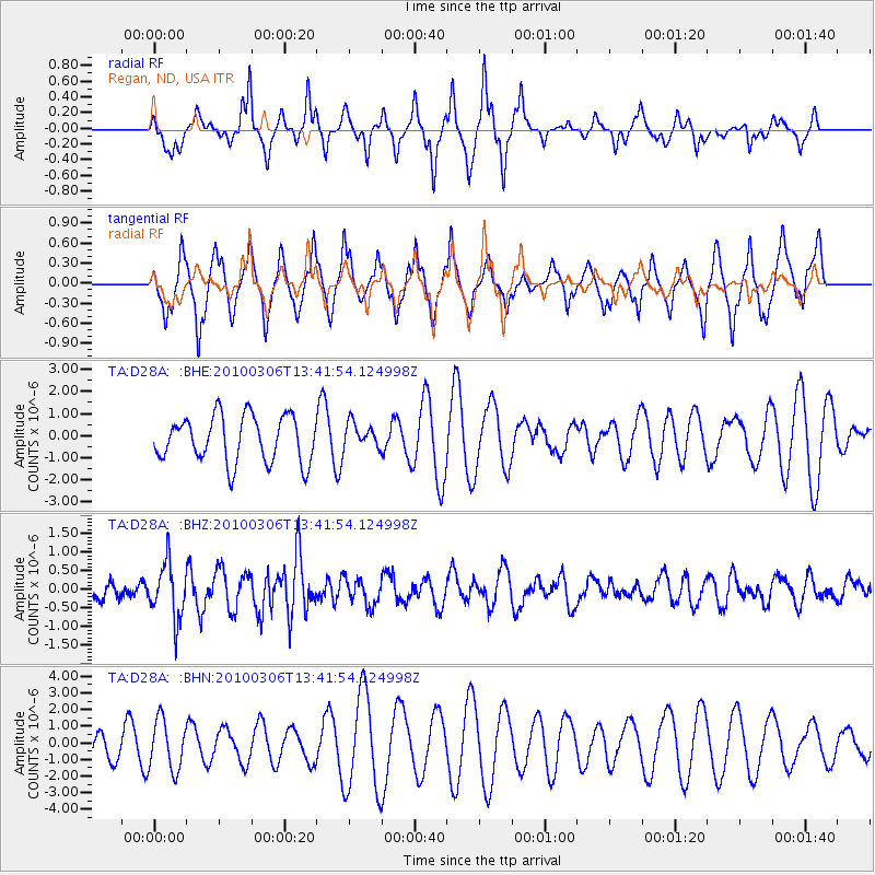
D28A Regan, ND, USA - Earthquake Result Viewer
*The percent match for this event was below the threshold and hence no stack was calculated.
| Earthquake location: |
Kuril Islands |
| Earthquake latitude/longitude: |
44.2/147.6 |
| Earthquake time(UTC): |
2010/03/06 (065) 13:31:12 GMT |
| Earthquake Depth: |
53 km |
| Earthquake Magnitude: |
5.7 MW, 5.1 MS, 5.4 MB, 5.6 MW |
| Earthquake Catalog/Contributor: |
WHDF/NEIC |
|
| Network: |
TA USArray Transportable Network (new EarthScope stations) |
| Station: |
D28A Regan, ND, USA |
| Lat/Lon: |
47.19 N/100.57 W |
| Elevation: |
621 m |
|
| Distance: |
71.0 deg |
| Az: |
42.054 deg |
| Baz: |
315.03 deg |
| Ray Param: |
$rayparam |
*The percent match for this event was below the threshold and hence was not used in the summary stack. |
|
| Radial Match: |
41.939003 % |
| Radial Bump: |
222 |
| Transverse Match: |
64.459564 % |
| Transverse Bump: |
400 |
| SOD ConfigId: |
299721 |
| Insert Time: |
2010-04-26 17:39:21.296 +0000 |
| GWidth: |
2.5 |
| Max Bumps: |
400 |
| Tol: |
0.001 |
|
Signal To Noise
| Channel | StoN | STA | LTA |
| TA:D28A: :BHZ:20100306T13:41:54.124998Z | 1.8610376 | 7.5237637E-7 | 4.042779E-7 |
| TA:D28A: :BHN:20100306T13:41:54.124998Z | 1.255282 | 1.4926985E-6 | 1.189134E-6 |
| TA:D28A: :BHE:20100306T13:41:54.124998Z | 0.54566205 | 5.668526E-7 | 1.0388345E-6 |
| Arrivals |
| Ps | |
| PpPs | |
| PsPs/PpSs | |


