You are here: Home > Network List > TA - USArray Transportable Network (new EarthScope stations) Stations List
> Station F28A McLaughlin, SD, USA > Earthquake Result Viewer
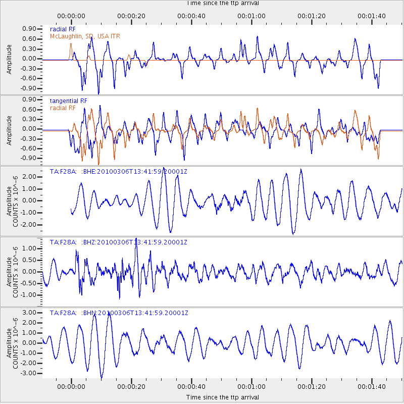
F28A McLaughlin, SD, USA - Earthquake Result Viewer
*The percent match for this event was below the threshold and hence no stack was calculated.
| Earthquake location: |
Kuril Islands |
| Earthquake latitude/longitude: |
44.2/147.6 |
| Earthquake time(UTC): |
2010/03/06 (065) 13:31:12 GMT |
| Earthquake Depth: |
53 km |
| Earthquake Magnitude: |
5.7 MW, 5.1 MS, 5.4 MB, 5.6 MW |
| Earthquake Catalog/Contributor: |
WHDF/NEIC |
|
| Network: |
TA USArray Transportable Network (new EarthScope stations) |
| Station: |
F28A McLaughlin, SD, USA |
| Lat/Lon: |
45.85 N/100.80 W |
| Elevation: |
633 m |
|
| Distance: |
71.8 deg |
| Az: |
43.174 deg |
| Baz: |
315.22 deg |
| Ray Param: |
$rayparam |
*The percent match for this event was below the threshold and hence was not used in the summary stack. |
|
| Radial Match: |
45.218445 % |
| Radial Bump: |
287 |
| Transverse Match: |
54.21749 % |
| Transverse Bump: |
400 |
| SOD ConfigId: |
299721 |
| Insert Time: |
2010-04-26 17:40:18.900 +0000 |
| GWidth: |
2.5 |
| Max Bumps: |
400 |
| Tol: |
0.001 |
|
Signal To Noise
| Channel | StoN | STA | LTA |
| TA:F28A: :BHZ:20100306T13:41:59.20001Z | 1.751004 | 4.5469116E-7 | 2.5967455E-7 |
| TA:F28A: :BHN:20100306T13:41:59.20001Z | 1.7188063 | 1.3728142E-6 | 7.987021E-7 |
| TA:F28A: :BHE:20100306T13:41:59.20001Z | 2.900866 | 1.7846274E-6 | 6.1520507E-7 |
| Arrivals |
| Ps | |
| PpPs | |
| PsPs/PpSs | |


